You are here: Home > Network List > TA - USArray Transportable Network (new EarthScope stations) Stations List
> Station E16A East Helena, MT, USA > Earthquake Result Viewer
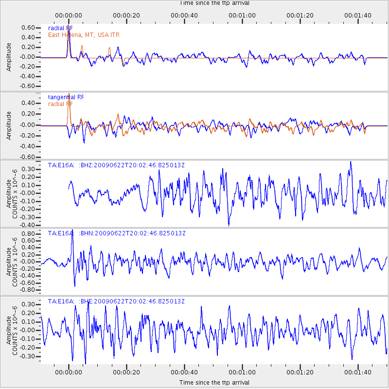
E16A East Helena, MT, USA - Earthquake Result Viewer
*The percent match for this event was below the threshold and hence no stack was calculated.
| Earthquake location: |
Andreanof Islands, Aleutian Is. |
| Earthquake latitude/longitude: |
51.3/-178.2 |
| Earthquake time(UTC): |
2009/06/22 (173) 19:55:24 GMT |
| Earthquake Depth: |
35 km |
| Earthquake Magnitude: |
5.6 MB, 5.6 MW, 5.6 MW |
| Earthquake Catalog/Contributor: |
WHDF/NEIC |
|
| Network: |
TA USArray Transportable Network (new EarthScope stations) |
| Station: |
E16A East Helena, MT, USA |
| Lat/Lon: |
46.53 N/111.68 W |
| Elevation: |
1398 m |
|
| Distance: |
42.6 deg |
| Az: |
69.209 deg |
| Baz: |
301.725 deg |
| Ray Param: |
$rayparam |
*The percent match for this event was below the threshold and hence was not used in the summary stack. |
|
| Radial Match: |
65.3488 % |
| Radial Bump: |
400 |
| Transverse Match: |
51.92466 % |
| Transverse Bump: |
400 |
| SOD ConfigId: |
2648 |
| Insert Time: |
2010-03-06 22:01:50.451 +0000 |
| GWidth: |
2.5 |
| Max Bumps: |
400 |
| Tol: |
0.001 |
|
Signal To Noise
| Channel | StoN | STA | LTA |
| TA:E16A: :BHN:20090622T20:02:46.825013Z | 4.6175203 | 3.349278E-7 | 7.253413E-8 |
| TA:E16A: :BHE:20090622T20:02:46.825013Z | 1.5814166 | 1.5030457E-7 | 9.504426E-8 |
| TA:E16A: :BHZ:20090622T20:02:46.825013Z | 1.7526063 | 1.2983067E-7 | 7.407863E-8 |
| Arrivals |
| Ps | |
| PpPs | |
| PsPs/PpSs | |


