You are here: Home > Network List > TA - USArray Transportable Network (new EarthScope stations) Stations List
> Station E16A East Helena, MT, USA > Earthquake Result Viewer
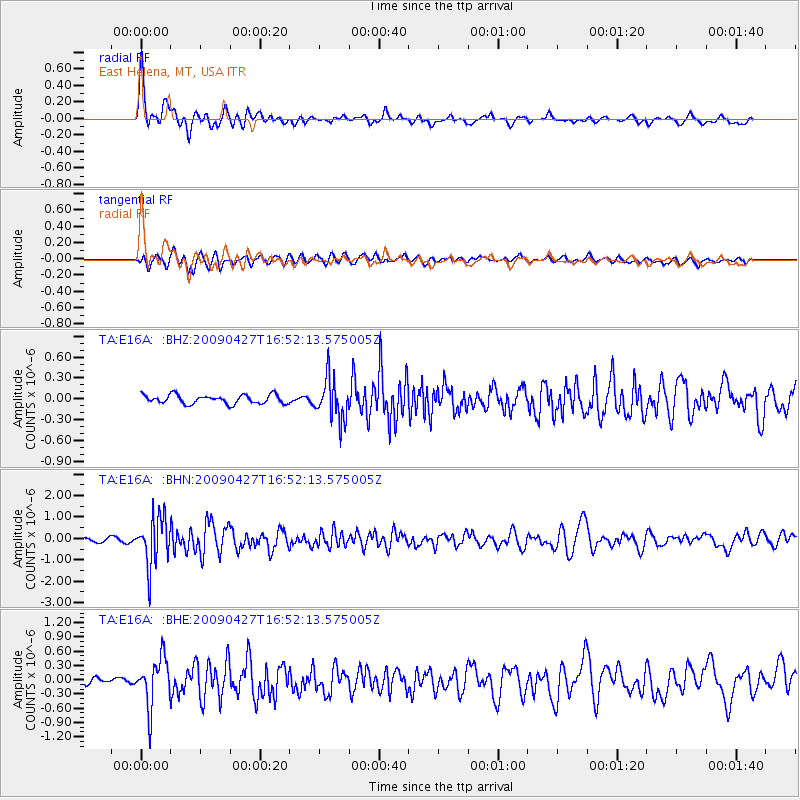
E16A East Helena, MT, USA - Earthquake Result Viewer
*The percent match for this event was below the threshold and hence no stack was calculated.
| Earthquake location: |
Guerrero, Mexico |
| Earthquake latitude/longitude: |
17.0/-99.4 |
| Earthquake time(UTC): |
2009/04/27 (117) 16:46:28 GMT |
| Earthquake Depth: |
35 km |
| Earthquake Magnitude: |
5.7 MB, 5.4 MS, 5.8 MW, 5.8 MW |
| Earthquake Catalog/Contributor: |
WHDF/NEIC |
|
| Network: |
TA USArray Transportable Network (new EarthScope stations) |
| Station: |
E16A East Helena, MT, USA |
| Lat/Lon: |
46.53 N/111.68 W |
| Elevation: |
1398 m |
|
| Distance: |
31.1 deg |
| Az: |
343.563 deg |
| Baz: |
156.913 deg |
| Ray Param: |
$rayparam |
*The percent match for this event was below the threshold and hence was not used in the summary stack. |
|
| Radial Match: |
77.49601 % |
| Radial Bump: |
400 |
| Transverse Match: |
61.365803 % |
| Transverse Bump: |
400 |
| SOD ConfigId: |
2658 |
| Insert Time: |
2010-03-06 22:01:56.333 +0000 |
| GWidth: |
2.5 |
| Max Bumps: |
400 |
| Tol: |
0.001 |
|
Signal To Noise
| Channel | StoN | STA | LTA |
| TA:E16A: :BHN:20090427T16:52:13.575005Z | 17.5266 | 1.1250361E-6 | 6.41902E-8 |
| TA:E16A: :BHE:20090427T16:52:13.575005Z | 7.241623 | 5.1654007E-7 | 7.1329325E-8 |
| TA:E16A: :BHZ:20090427T16:52:13.575005Z | 4.6450467 | 2.9607347E-7 | 6.373961E-8 |
| Arrivals |
| Ps | |
| PpPs | |
| PsPs/PpSs | |


