You are here: Home > Network List > TA - USArray Transportable Network (new EarthScope stations) Stations List
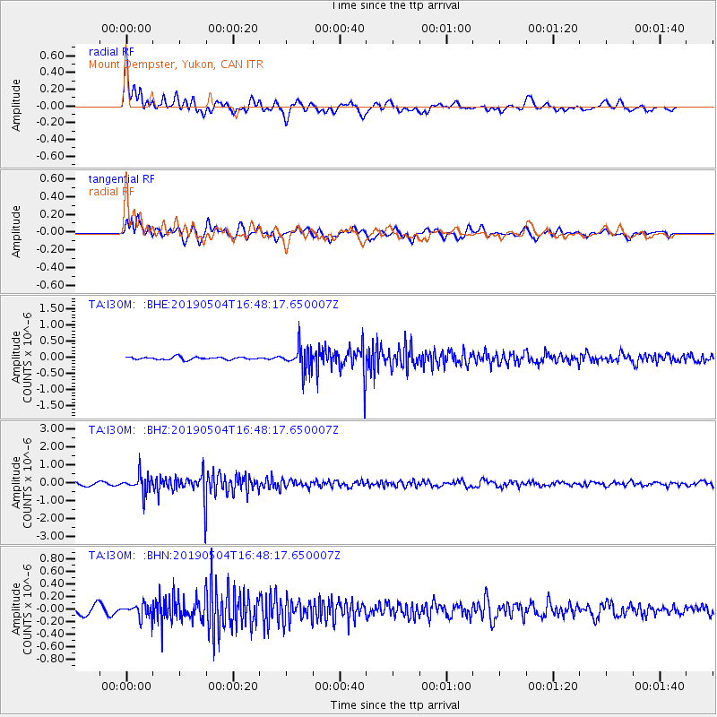
> Station I30M Mount Dempster, Yukon, CAN > Earthquake Result Viewer
I30M Mount Dempster, Yukon, CAN - Earthquake Result Viewer
| Earthquake location: |
Kuril Islands |
| Earthquake latitude/longitude: |
43.2/146.4 |
| Earthquake time(UTC): |
2019/05/04 (124) 16:40:25 GMT |
| Earthquake Depth: |
59 km |
| Earthquake Magnitude: |
5.1 Mww |
| Earthquake Catalog/Contributor: |
NEIC PDE/us |
|
| Network: |
TA USArray Transportable Network (new EarthScope stations) |
| Station: |
I30M Mount Dempster, Yukon, CAN |
| Lat/Lon: |
65.22 N/136.38 W |
| Elevation: |
1399 m |
|
| Distance: |
46.6 deg |
| Az: |
34.419 deg |
| Baz: |
281.122 deg |
| Ray Param: |
0.07034803 |
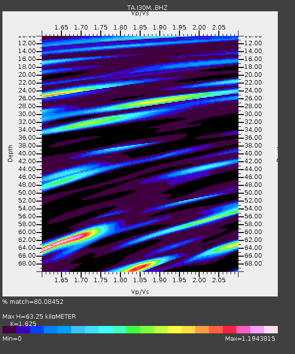
| Estimated Moho Depth: |
63.25 km |
| Estimated Crust Vp/Vs: |
1.62 |
| Assumed Crust Vp: |
6.566 km/s |
| Estimated Crust Vs: |
4.041 km/s |
| Estimated Crust Poisson's Ratio: |
0.20 |
|
| Radial Match: |
80.08452 % |
| Radial Bump: |
400 |
| Transverse Match: |
65.73221 % |
| Transverse Bump: |
400 |
| SOD ConfigId: |
18252611 |
| Insert Time: |
2019-05-18 16:47:08.584 +0000 |
| GWidth: |
2.5 |
| Max Bumps: |
400 |
| Tol: |
0.001 |
|
Signal To Noise
| Channel | StoN | STA | LTA |
| TA:I30M: :BHZ:20190504T16:48:17.650007Z | 5.343706 | 5.047698E-7 | 9.4460624E-8 |
| TA:I30M: :BHN:20190504T16:48:17.650007Z | 1.6889495 | 1.1240433E-7 | 6.655281E-8 |
| TA:I30M: :BHE:20190504T16:48:17.650007Z | 8.64288 | 3.5362015E-7 | 4.0914617E-8 |
| Arrivals |
| Ps | 6.5 SECOND |
| PpPs | 24 SECOND |
| PsPs/PpSs | 30 SECOND |


