You are here: Home > Network List > TA - USArray Transportable Network (new EarthScope stations) Stations List
> Station J26L Joseph Creek, AK, USA > Earthquake Result Viewer
J26L Joseph Creek, AK, USA - Earthquake Result Viewer
*The percent match for this event was below the threshold and hence no stack was calculated.
| Earthquake location: |
Kuril Islands |
| Earthquake latitude/longitude: |
43.2/146.4 |
| Earthquake time(UTC): |
2019/05/04 (124) 16:40:25 GMT |
| Earthquake Depth: |
59 km |
| Earthquake Magnitude: |
5.1 Mww |
| Earthquake Catalog/Contributor: |
NEIC PDE/us |
|
| Network: |
TA USArray Transportable Network (new EarthScope stations) |
| Station: |
J26L Joseph Creek, AK, USA |
| Lat/Lon: |
64.50 N/143.56 W |
| Elevation: |
1144 m |
|
| Distance: |
43.7 deg |
| Az: |
36.063 deg |
| Baz: |
275.782 deg |
| Ray Param: |
$rayparam |
*The percent match for this event was below the threshold and hence was not used in the summary stack. |
|
| Radial Match: |
56.210945 % |
| Radial Bump: |
400 |
| Transverse Match: |
63.891235 % |
| Transverse Bump: |
400 |
| SOD ConfigId: |
18252611 |
| Insert Time: |
2019-05-18 16:47:15.137 +0000 |
| GWidth: |
2.5 |
| Max Bumps: |
400 |
| Tol: |
0.001 |
|
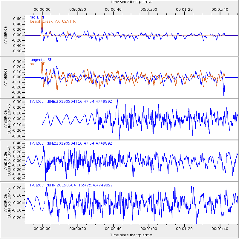
Signal To Noise
| Channel | StoN | STA | LTA |
| TA:J26L: :BHZ:20190504T16:47:54.474989Z | 2.212274 | 1.55579E-7 | 7.032537E-8 |
| TA:J26L: :BHN:20190504T16:47:54.474989Z | 2.1972692 | 1.0619111E-7 | 4.8328676E-8 |
| TA:J26L: :BHE:20190504T16:47:54.474989Z | 1.675003 | 9.527036E-8 | 5.687772E-8 |
| Arrivals |
| Ps | |
| PpPs | |
| PsPs/PpSs | |


