You are here: Home > Network List > TA - USArray Transportable Network (new EarthScope stations) Stations List
> Station M16K Timber Creek, AK, USA > Earthquake Result Viewer
M16K Timber Creek, AK, USA - Earthquake Result Viewer
*The percent match for this event was below the threshold and hence no stack was calculated.
| Earthquake location: |
Kuril Islands |
| Earthquake latitude/longitude: |
43.2/146.4 |
| Earthquake time(UTC): |
2019/05/04 (124) 16:40:25 GMT |
| Earthquake Depth: |
59 km |
| Earthquake Magnitude: |
5.1 Mww |
| Earthquake Catalog/Contributor: |
NEIC PDE/us |
|
| Network: |
TA USArray Transportable Network (new EarthScope stations) |
| Station: |
M16K Timber Creek, AK, USA |
| Lat/Lon: |
61.02 N/158.96 W |
| Elevation: |
394 m |
|
| Distance: |
36.7 deg |
| Az: |
41.628 deg |
| Baz: |
266.349 deg |
| Ray Param: |
$rayparam |
*The percent match for this event was below the threshold and hence was not used in the summary stack. |
|
| Radial Match: |
60.544777 % |
| Radial Bump: |
400 |
| Transverse Match: |
51.688377 % |
| Transverse Bump: |
400 |
| SOD ConfigId: |
18252611 |
| Insert Time: |
2019-05-18 16:47:25.432 +0000 |
| GWidth: |
2.5 |
| Max Bumps: |
400 |
| Tol: |
0.001 |
|
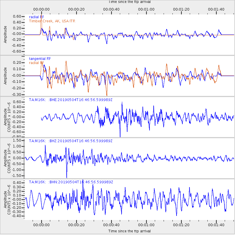
Signal To Noise
| Channel | StoN | STA | LTA |
| TA:M16K: :BHZ:20190504T16:46:56.599989Z | 4.2218604 | 3.5659977E-7 | 8.446508E-8 |
| TA:M16K: :BHN:20190504T16:46:56.599989Z | 1.2634649 | 1.2197714E-7 | 9.654177E-8 |
| TA:M16K: :BHE:20190504T16:46:56.599989Z | 2.2173808 | 2.1296225E-7 | 9.604226E-8 |
| Arrivals |
| Ps | |
| PpPs | |
| PsPs/PpSs | |


