You are here: Home > Network List > US - United States National Seismic Network Stations List
> Station HAWA Hanford, Washington, USA > Earthquake Result Viewer
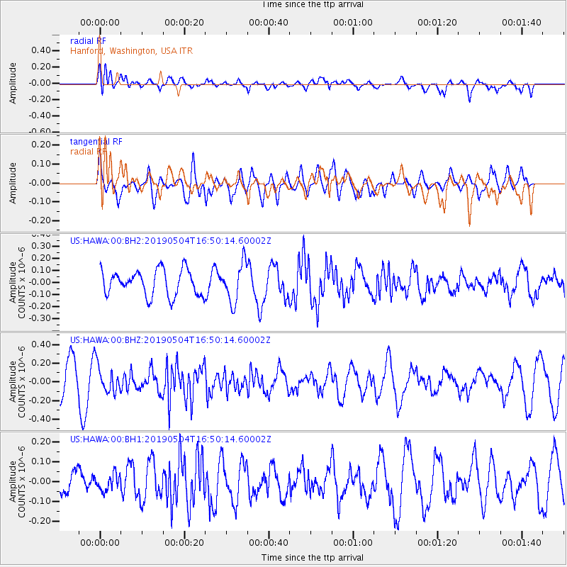
HAWA Hanford, Washington, USA - Earthquake Result Viewer
*The percent match for this event was below the threshold and hence no stack was calculated.
| Earthquake location: |
Kuril Islands |
| Earthquake latitude/longitude: |
43.2/146.4 |
| Earthquake time(UTC): |
2019/05/04 (124) 16:40:25 GMT |
| Earthquake Depth: |
59 km |
| Earthquake Magnitude: |
5.1 Mww |
| Earthquake Catalog/Contributor: |
NEIC PDE/us |
|
| Network: |
US United States National Seismic Network |
| Station: |
HAWA Hanford, Washington, USA |
| Lat/Lon: |
46.39 N/119.53 W |
| Elevation: |
364 m |
|
| Distance: |
62.8 deg |
| Az: |
50.893 deg |
| Baz: |
304.899 deg |
| Ray Param: |
$rayparam |
*The percent match for this event was below the threshold and hence was not used in the summary stack. |
|
| Radial Match: |
79.88151 % |
| Radial Bump: |
400 |
| Transverse Match: |
53.127323 % |
| Transverse Bump: |
400 |
| SOD ConfigId: |
18252611 |
| Insert Time: |
2019-05-18 16:48:19.819 +0000 |
| GWidth: |
2.5 |
| Max Bumps: |
400 |
| Tol: |
0.001 |
|
Signal To Noise
| Channel | StoN | STA | LTA |
| US:HAWA:00:BHZ:20190504T16:50:14.60002Z | 0.6341022 | 1.2942918E-7 | 2.0411404E-7 |
| US:HAWA:00:BH1:20190504T16:50:14.60002Z | 0.5643419 | 4.061956E-8 | 7.1976864E-8 |
| US:HAWA:00:BH2:20190504T16:50:14.60002Z | 1.5573251 | 1.6520167E-7 | 1.060804E-7 |
| Arrivals |
| Ps | |
| PpPs | |
| PsPs/PpSs | |


