You are here: Home > Network List > TA - USArray Transportable Network (new EarthScope stations) Stations List
> Station E16A East Helena, MT, USA > Earthquake Result Viewer
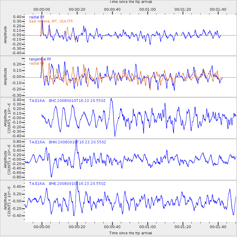
E16A East Helena, MT, USA - Earthquake Result Viewer
*The percent match for this event was below the threshold and hence no stack was calculated.
| Earthquake location: |
Northern Chile |
| Earthquake latitude/longitude: |
-20.3/-69.2 |
| Earthquake time(UTC): |
2008/09/10 (254) 16:12:04 GMT |
| Earthquake Depth: |
38 km |
| Earthquake Magnitude: |
5.6 MB, 5.3 MS |
| Earthquake Catalog/Contributor: |
WHDF/NEIC |
|
| Network: |
TA USArray Transportable Network (new EarthScope stations) |
| Station: |
E16A East Helena, MT, USA |
| Lat/Lon: |
46.53 N/111.68 W |
| Elevation: |
1398 m |
|
| Distance: |
76.8 deg |
| Az: |
331.398 deg |
| Baz: |
139.38 deg |
| Ray Param: |
$rayparam |
*The percent match for this event was below the threshold and hence was not used in the summary stack. |
|
| Radial Match: |
63.696472 % |
| Radial Bump: |
400 |
| Transverse Match: |
62.441895 % |
| Transverse Bump: |
400 |
| SOD ConfigId: |
2560 |
| Insert Time: |
2010-03-06 22:02:31.477 +0000 |
| GWidth: |
2.5 |
| Max Bumps: |
400 |
| Tol: |
0.001 |
|
Signal To Noise
| Channel | StoN | STA | LTA |
| TA:E16A: :BHN:20080910T16:23:20.550Z | 2.8991952 | 2.5873354E-7 | 8.924322E-8 |
| TA:E16A: :BHE:20080910T16:23:20.550Z | 1.8638203 | 1.5793377E-7 | 8.4736584E-8 |
| TA:E16A: :BHZ:20080910T16:23:20.550Z | 0.715661 | 1.0509131E-7 | 1.468451E-7 |
| Arrivals |
| Ps | |
| PpPs | |
| PsPs/PpSs | |


