You are here: Home > Network List > TA - USArray Transportable Network (new EarthScope stations) Stations List
> Station E16A East Helena, MT, USA > Earthquake Result Viewer
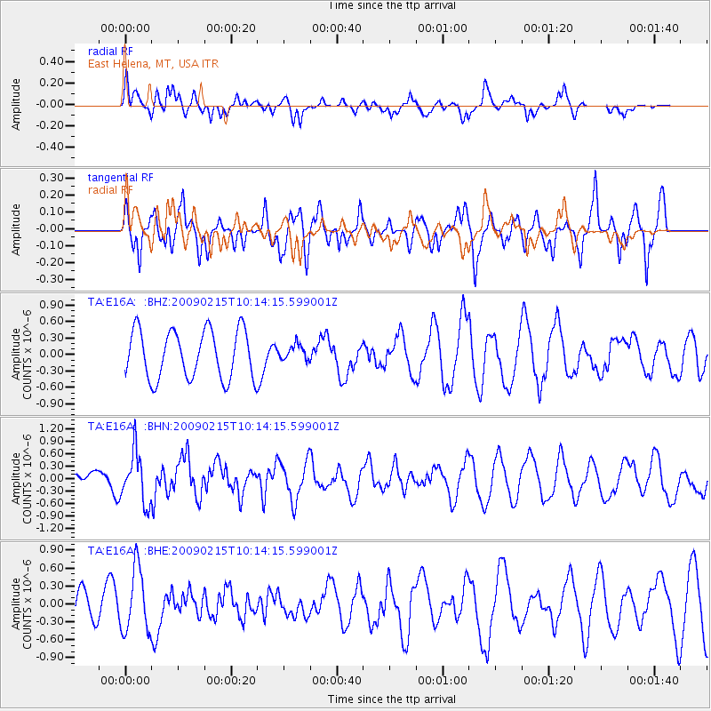
E16A East Helena, MT, USA - Earthquake Result Viewer
*The percent match for this event was below the threshold and hence no stack was calculated.
| Earthquake location: |
Near Coast Of Northern Peru |
| Earthquake latitude/longitude: |
-5.9/-80.9 |
| Earthquake time(UTC): |
2009/02/15 (046) 10:04:49 GMT |
| Earthquake Depth: |
21 km |
| Earthquake Magnitude: |
5.8 MB, 5.7 MS, 6.1 MW, 6.1 MW |
| Earthquake Catalog/Contributor: |
WHDF/NEIC |
|
| Network: |
TA USArray Transportable Network (new EarthScope stations) |
| Station: |
E16A East Helena, MT, USA |
| Lat/Lon: |
46.53 N/111.68 W |
| Elevation: |
1398 m |
|
| Distance: |
58.9 deg |
| Az: |
335.625 deg |
| Baz: |
143.506 deg |
| Ray Param: |
$rayparam |
*The percent match for this event was below the threshold and hence was not used in the summary stack. |
|
| Radial Match: |
58.617794 % |
| Radial Bump: |
400 |
| Transverse Match: |
71.31478 % |
| Transverse Bump: |
400 |
| SOD ConfigId: |
2658 |
| Insert Time: |
2010-03-06 22:02:35.416 +0000 |
| GWidth: |
2.5 |
| Max Bumps: |
400 |
| Tol: |
0.001 |
|
Signal To Noise
| Channel | StoN | STA | LTA |
| TA:E16A: :BHN:20090215T10:14:15.599001Z | 2.6563697 | 6.085858E-7 | 2.2910432E-7 |
| TA:E16A: :BHE:20090215T10:14:15.599001Z | 1.4619083 | 5.3734294E-7 | 3.6756268E-7 |
| TA:E16A: :BHZ:20090215T10:14:15.599001Z | 0.32149547 | 1.40978E-7 | 4.3850696E-7 |
| Arrivals |
| Ps | |
| PpPs | |
| PsPs/PpSs | |


