You are here: Home > Network List > TA - USArray Transportable Network (new EarthScope stations) Stations List
> Station E16A East Helena, MT, USA > Earthquake Result Viewer
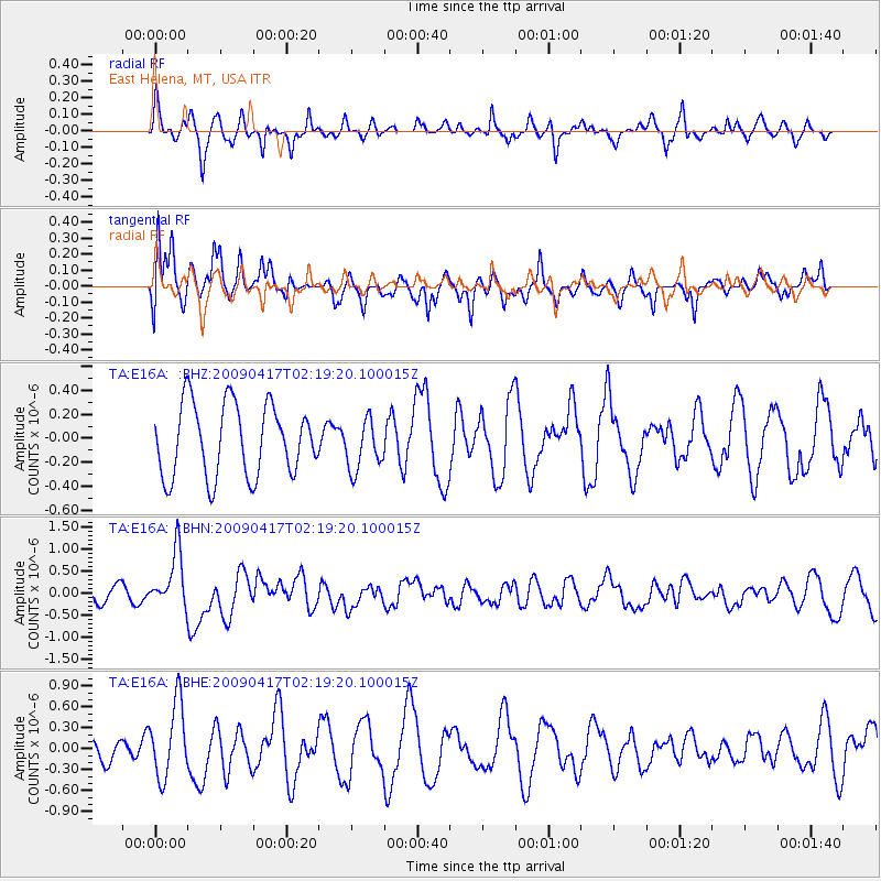
E16A East Helena, MT, USA - Earthquake Result Viewer
*The percent match for this event was below the threshold and hence no stack was calculated.
| Earthquake location: |
Near Coast Of Northern Chile |
| Earthquake latitude/longitude: |
-19.6/-70.5 |
| Earthquake time(UTC): |
2009/04/17 (107) 02:08:08 GMT |
| Earthquake Depth: |
25 km |
| Earthquake Magnitude: |
5.8 MB, 5.8 MS, 6.1 MW, 6.1 MW |
| Earthquake Catalog/Contributor: |
WHDF/NEIC |
|
| Network: |
TA USArray Transportable Network (new EarthScope stations) |
| Station: |
E16A East Helena, MT, USA |
| Lat/Lon: |
46.53 N/111.68 W |
| Elevation: |
1398 m |
|
| Distance: |
75.6 deg |
| Az: |
332.003 deg |
| Baz: |
140.125 deg |
| Ray Param: |
$rayparam |
*The percent match for this event was below the threshold and hence was not used in the summary stack. |
|
| Radial Match: |
66.72696 % |
| Radial Bump: |
370 |
| Transverse Match: |
56.060307 % |
| Transverse Bump: |
400 |
| SOD ConfigId: |
2658 |
| Insert Time: |
2010-03-06 22:02:39.803 +0000 |
| GWidth: |
2.5 |
| Max Bumps: |
400 |
| Tol: |
0.001 |
|
Signal To Noise
| Channel | StoN | STA | LTA |
| TA:E16A: :BHN:20090417T02:19:20.100015Z | 2.317025 | 6.355873E-7 | 2.7431182E-7 |
| TA:E16A: :BHE:20090417T02:19:20.100015Z | 1.9988384 | 5.332563E-7 | 2.667831E-7 |
| TA:E16A: :BHZ:20090417T02:19:20.100015Z | 0.69617385 | 2.086999E-7 | 2.9978128E-7 |
| Arrivals |
| Ps | |
| PpPs | |
| PsPs/PpSs | |


