You are here: Home > Network List > TA - USArray Transportable Network (new EarthScope stations) Stations List
> Station I17A Pilgram Creek (NPS), Teton National Park, WY, USA > Earthquake Result Viewer
I17A Pilgram Creek (NPS), Teton National Park, WY, USA - Earthquake Result Viewer
| Earthquake location: |
Vanuatu Islands |
| Earthquake latitude/longitude: |
-13.5/167.0 |
| Earthquake time(UTC): |
2008/09/08 (252) 18:52:06 GMT |
| Earthquake Depth: |
110 km |
| Earthquake Magnitude: |
6.4 MB, 6.9 MW, 6.9 MW |
| Earthquake Catalog/Contributor: |
WHDF/NEIC |
|
| Network: |
TA USArray Transportable Network (new EarthScope stations) |
| Station: |
I17A Pilgram Creek (NPS), Teton National Park, WY, USA |
| Lat/Lon: |
43.92 N/110.58 W |
| Elevation: |
2134 m |
|
| Distance: |
93.9 deg |
| Az: |
45.893 deg |
| Baz: |
255.138 deg |
| Ray Param: |
0.041097827 |
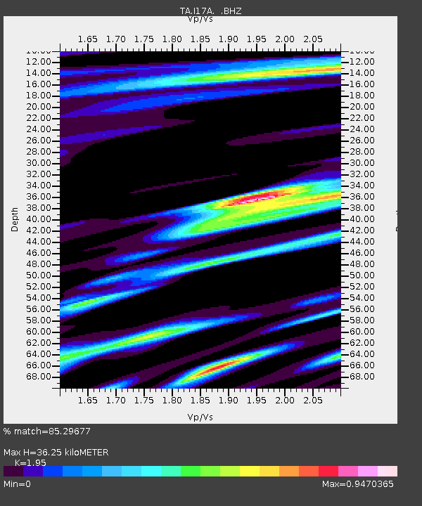
| Estimated Moho Depth: |
36.25 km |
| Estimated Crust Vp/Vs: |
1.95 |
| Assumed Crust Vp: |
6.207 km/s |
| Estimated Crust Vs: |
3.183 km/s |
| Estimated Crust Poisson's Ratio: |
0.32 |
|
| Radial Match: |
85.29677 % |
| Radial Bump: |
400 |
| Transverse Match: |
81.1752 % |
| Transverse Bump: |
400 |
| SOD ConfigId: |
2560 |
| Insert Time: |
2010-03-06 22:02:49.513 +0000 |
| GWidth: |
2.5 |
| Max Bumps: |
400 |
| Tol: |
0.001 |
|

Signal To Noise
| Channel | StoN | STA | LTA |
| TA:I17A: :BHZ:20080908T19:04:40.824004Z | 18.946705 | 2.5691006E-6 | 1.3559617E-7 |
| TA:I17A: :BHN:20080908T19:04:40.824004Z | 1.7692533 | 4.9248496E-7 | 2.783575E-7 |
| TA:I17A: :BHE:20080908T19:04:40.824004Z | 2.3890798 | 6.5341317E-7 | 2.7349992E-7 |
| Arrivals |
| Ps | 5.6 SECOND |
| PpPs | 17 SECOND |
| PsPs/PpSs | 23 SECOND |


