You are here: Home > Network List > TA - USArray Transportable Network (new EarthScope stations) Stations List
> Station I17A Pilgram Creek (NPS), Teton National Park, WY, USA > Earthquake Result Viewer
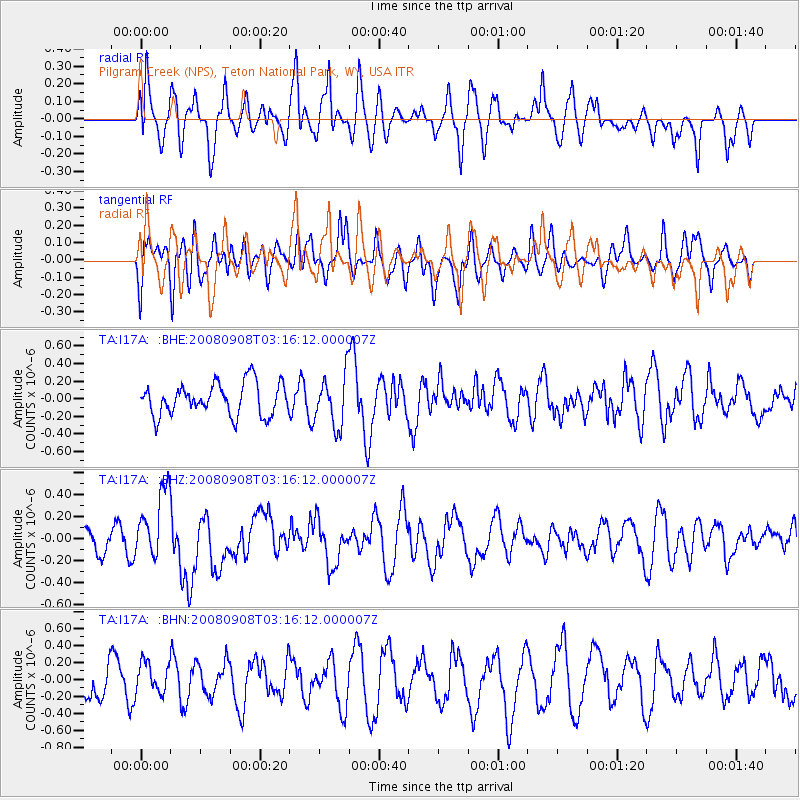
I17A Pilgram Creek (NPS), Teton National Park, WY, USA - Earthquake Result Viewer
*The percent match for this event was below the threshold and hence no stack was calculated.
| Earthquake location: |
Vanuatu Islands |
| Earthquake latitude/longitude: |
-20.0/169.1 |
| Earthquake time(UTC): |
2008/09/08 (252) 03:03:15 GMT |
| Earthquake Depth: |
36 km |
| Earthquake Magnitude: |
6.0 MB, 5.8 MS, 6.2 MW, 6.2 MW |
| Earthquake Catalog/Contributor: |
WHDF/NEIC |
|
| Network: |
TA USArray Transportable Network (new EarthScope stations) |
| Station: |
I17A Pilgram Creek (NPS), Teton National Park, WY, USA |
| Lat/Lon: |
43.92 N/110.58 W |
| Elevation: |
2134 m |
|
| Distance: |
96.9 deg |
| Az: |
45.852 deg |
| Baz: |
249.07 deg |
| Ray Param: |
$rayparam |
*The percent match for this event was below the threshold and hence was not used in the summary stack. |
|
| Radial Match: |
65.73401 % |
| Radial Bump: |
400 |
| Transverse Match: |
31.244345 % |
| Transverse Bump: |
400 |
| SOD ConfigId: |
2560 |
| Insert Time: |
2010-03-06 22:03:33.968 +0000 |
| GWidth: |
2.5 |
| Max Bumps: |
400 |
| Tol: |
0.001 |
|
Signal To Noise
| Channel | StoN | STA | LTA |
| TA:I17A: :BHZ:20080908T03:16:12.000007Z | 2.7890708 | 3.209538E-7 | 1.1507554E-7 |
| TA:I17A: :BHN:20080908T03:16:12.000007Z | 0.7607958 | 1.803031E-7 | 2.3699278E-7 |
| TA:I17A: :BHE:20080908T03:16:12.000007Z | 1.61275 | 2.927998E-7 | 1.8155312E-7 |
| Arrivals |
| Ps | |
| PpPs | |
| PsPs/PpSs | |


