You are here: Home > Network List > TA - USArray Transportable Network (new EarthScope stations) Stations List
> Station B18K Kokolik River, AK, USA > Earthquake Result Viewer
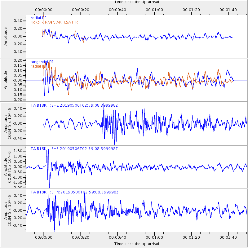
B18K Kokolik River, AK, USA - Earthquake Result Viewer
*The percent match for this event was below the threshold and hence no stack was calculated.
| Earthquake location: |
Luzon, Philippines |
| Earthquake latitude/longitude: |
18.7/120.9 |
| Earthquake time(UTC): |
2019/05/06 (126) 02:48:42 GMT |
| Earthquake Depth: |
35 km |
| Earthquake Magnitude: |
5.5 Mww |
| Earthquake Catalog/Contributor: |
NEIC PDE/us |
|
| Network: |
TA USArray Transportable Network (new EarthScope stations) |
| Station: |
B18K Kokolik River, AK, USA |
| Lat/Lon: |
69.36 N/161.80 W |
| Elevation: |
222 m |
|
| Distance: |
68.1 deg |
| Az: |
21.879 deg |
| Baz: |
264.975 deg |
| Ray Param: |
$rayparam |
*The percent match for this event was below the threshold and hence was not used in the summary stack. |
|
| Radial Match: |
64.81614 % |
| Radial Bump: |
400 |
| Transverse Match: |
55.755547 % |
| Transverse Bump: |
400 |
| SOD ConfigId: |
18252611 |
| Insert Time: |
2019-05-20 02:51:59.521 +0000 |
| GWidth: |
2.5 |
| Max Bumps: |
400 |
| Tol: |
0.001 |
|
Signal To Noise
| Channel | StoN | STA | LTA |
| TA:B18K: :BHZ:20190506T02:59:08.399998Z | 8.047596 | 7.583288E-7 | 9.423048E-8 |
| TA:B18K: :BHN:20190506T02:59:08.399998Z | 1.9261193 | 1.6880954E-7 | 8.76423E-8 |
| TA:B18K: :BHE:20190506T02:59:08.399998Z | 2.2186701 | 1.8637871E-7 | 8.40047E-8 |
| Arrivals |
| Ps | |
| PpPs | |
| PsPs/PpSs | |


