You are here: Home > Network List > TA - USArray Transportable Network (new EarthScope stations) Stations List
> Station I17A Pilgram Creek (NPS), Teton National Park, WY, USA > Earthquake Result Viewer
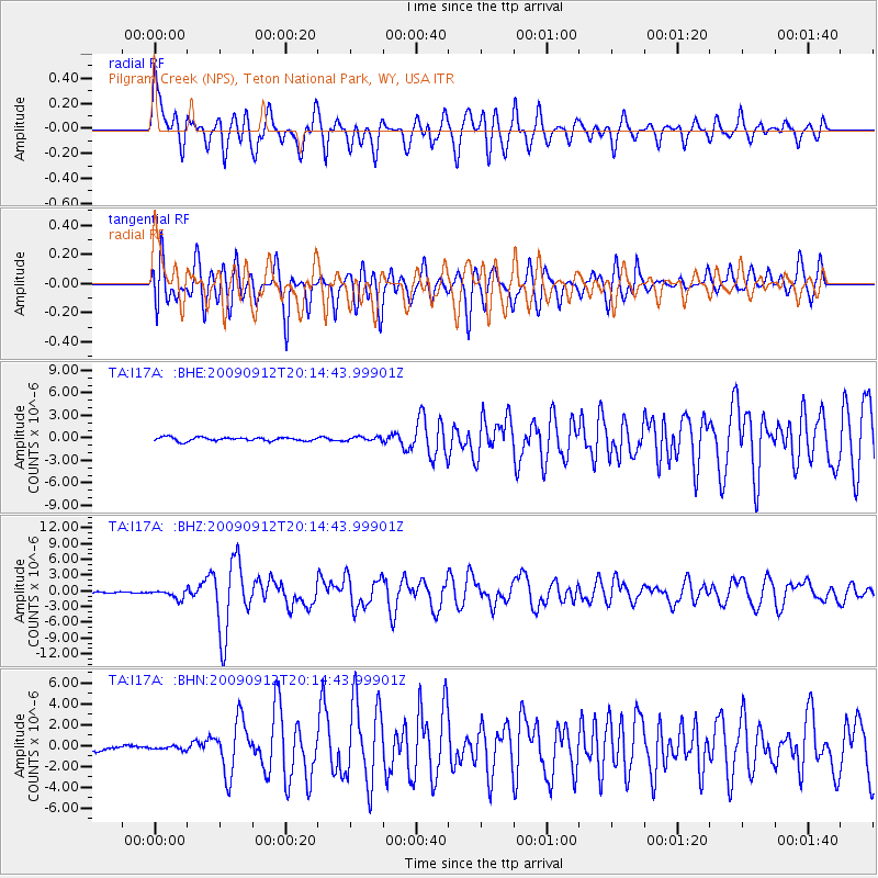
I17A Pilgram Creek (NPS), Teton National Park, WY, USA - Earthquake Result Viewer
*The percent match for this event was below the threshold and hence no stack was calculated.
| Earthquake location: |
Near Coast Of Venezuela |
| Earthquake latitude/longitude: |
10.7/-67.9 |
| Earthquake time(UTC): |
2009/09/12 (255) 20:06:24 GMT |
| Earthquake Depth: |
10 km |
| Earthquake Magnitude: |
6.3 MB, 6.4 MS, 6.3 MW, 6.3 MW |
| Earthquake Catalog/Contributor: |
WHDF/NEIC |
|
| Network: |
TA USArray Transportable Network (new EarthScope stations) |
| Station: |
I17A Pilgram Creek (NPS), Teton National Park, WY, USA |
| Lat/Lon: |
43.92 N/110.58 W |
| Elevation: |
2134 m |
|
| Distance: |
49.5 deg |
| Az: |
319.89 deg |
| Baz: |
118.81 deg |
| Ray Param: |
$rayparam |
*The percent match for this event was below the threshold and hence was not used in the summary stack. |
|
| Radial Match: |
77.51853 % |
| Radial Bump: |
400 |
| Transverse Match: |
79.10955 % |
| Transverse Bump: |
400 |
| SOD ConfigId: |
2622 |
| Insert Time: |
2010-03-06 22:04:09.667 +0000 |
| GWidth: |
2.5 |
| Max Bumps: |
400 |
| Tol: |
0.001 |
|
Signal To Noise
| Channel | StoN | STA | LTA |
| TA:I17A: :BHZ:20090912T20:14:43.99901Z | 4.8807387 | 8.289192E-7 | 1.6983479E-7 |
| TA:I17A: :BHN:20090912T20:14:43.99901Z | 0.78038365 | 1.6873815E-7 | 2.1622462E-7 |
| TA:I17A: :BHE:20090912T20:14:43.99901Z | 1.13331 | 2.7856825E-7 | 2.4580058E-7 |
| Arrivals |
| Ps | |
| PpPs | |
| PsPs/PpSs | |


