You are here: Home > Network List > TA - USArray Transportable Network (new EarthScope stations) Stations List
> Station G21K Allakaket, AK, USA > Earthquake Result Viewer
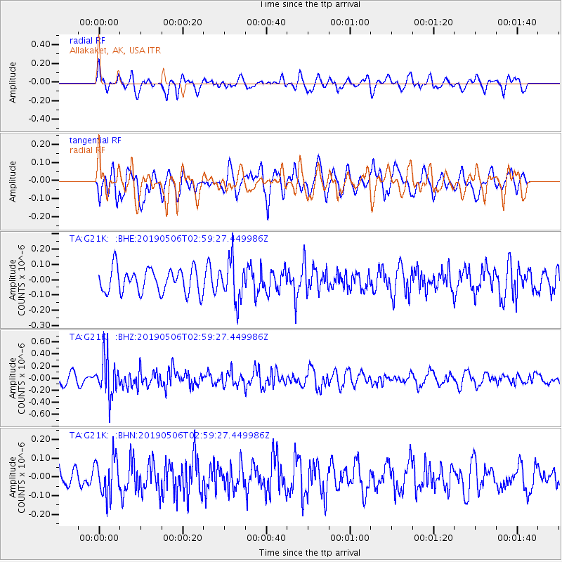
G21K Allakaket, AK, USA - Earthquake Result Viewer
*The percent match for this event was below the threshold and hence no stack was calculated.
| Earthquake location: |
Luzon, Philippines |
| Earthquake latitude/longitude: |
18.7/120.9 |
| Earthquake time(UTC): |
2019/05/06 (126) 02:48:42 GMT |
| Earthquake Depth: |
35 km |
| Earthquake Magnitude: |
5.5 Mww |
| Earthquake Catalog/Contributor: |
NEIC PDE/us |
|
| Network: |
TA USArray Transportable Network (new EarthScope stations) |
| Station: |
G21K Allakaket, AK, USA |
| Lat/Lon: |
66.52 N/153.51 W |
| Elevation: |
446 m |
|
| Distance: |
71.2 deg |
| Az: |
24.96 deg |
| Baz: |
273.73 deg |
| Ray Param: |
$rayparam |
*The percent match for this event was below the threshold and hence was not used in the summary stack. |
|
| Radial Match: |
51.573948 % |
| Radial Bump: |
400 |
| Transverse Match: |
60.2037 % |
| Transverse Bump: |
400 |
| SOD ConfigId: |
18252611 |
| Insert Time: |
2019-05-20 02:52:26.825 +0000 |
| GWidth: |
2.5 |
| Max Bumps: |
400 |
| Tol: |
0.001 |
|
Signal To Noise
| Channel | StoN | STA | LTA |
| TA:G21K: :BHZ:20190506T02:59:27.449986Z | 4.9131985 | 3.1779098E-7 | 6.468108E-8 |
| TA:G21K: :BHN:20190506T02:59:27.449986Z | 2.2904136 | 1.0077689E-7 | 4.3999428E-8 |
| TA:G21K: :BHE:20190506T02:59:27.449986Z | 1.6919912 | 1.3445727E-7 | 7.9466886E-8 |
| Arrivals |
| Ps | |
| PpPs | |
| PsPs/PpSs | |


