You are here: Home > Network List > TA - USArray Transportable Network (new EarthScope stations) Stations List
> Station I17A Pilgram Creek (NPS), Teton National Park, WY, USA > Earthquake Result Viewer
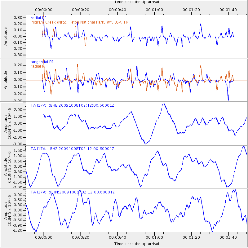
I17A Pilgram Creek (NPS), Teton National Park, WY, USA - Earthquake Result Viewer
*The percent match for this event was below the threshold and hence no stack was calculated.
| Earthquake location: |
Santa Cruz Islands |
| Earthquake latitude/longitude: |
-11.9/166.0 |
| Earthquake time(UTC): |
2009/10/08 (281) 01:59:19 GMT |
| Earthquake Depth: |
35 km |
| Earthquake Magnitude: |
5.9 MB |
| Earthquake Catalog/Contributor: |
WHDF/NEIC |
|
| Network: |
TA USArray Transportable Network (new EarthScope stations) |
| Station: |
I17A Pilgram Creek (NPS), Teton National Park, WY, USA |
| Lat/Lon: |
43.92 N/110.58 W |
| Elevation: |
2134 m |
|
| Distance: |
93.5 deg |
| Az: |
45.995 deg |
| Baz: |
256.97 deg |
| Ray Param: |
$rayparam |
*The percent match for this event was below the threshold and hence was not used in the summary stack. |
|
| Radial Match: |
36.379894 % |
| Radial Bump: |
292 |
| Transverse Match: |
56.229473 % |
| Transverse Bump: |
387 |
| SOD ConfigId: |
2622 |
| Insert Time: |
2010-03-06 22:04:20.422 +0000 |
| GWidth: |
2.5 |
| Max Bumps: |
400 |
| Tol: |
0.001 |
|
Signal To Noise
| Channel | StoN | STA | LTA |
| TA:I17A: :BHZ:20091008T02:12:00.60001Z | 0.60532236 | 9.1835847E-7 | 1.5171395E-6 |
| TA:I17A: :BHN:20091008T02:12:00.60001Z | 0.6766251 | 4.4305668E-7 | 6.548038E-7 |
| TA:I17A: :BHE:20091008T02:12:00.60001Z | 1.1349458 | 8.542369E-7 | 7.5266763E-7 |
| Arrivals |
| Ps | |
| PpPs | |
| PsPs/PpSs | |


