You are here: Home > Network List > IW - Intermountain West Stations List
> Station MOOW Moose Ponds, Wyoming, USA > Earthquake Result Viewer
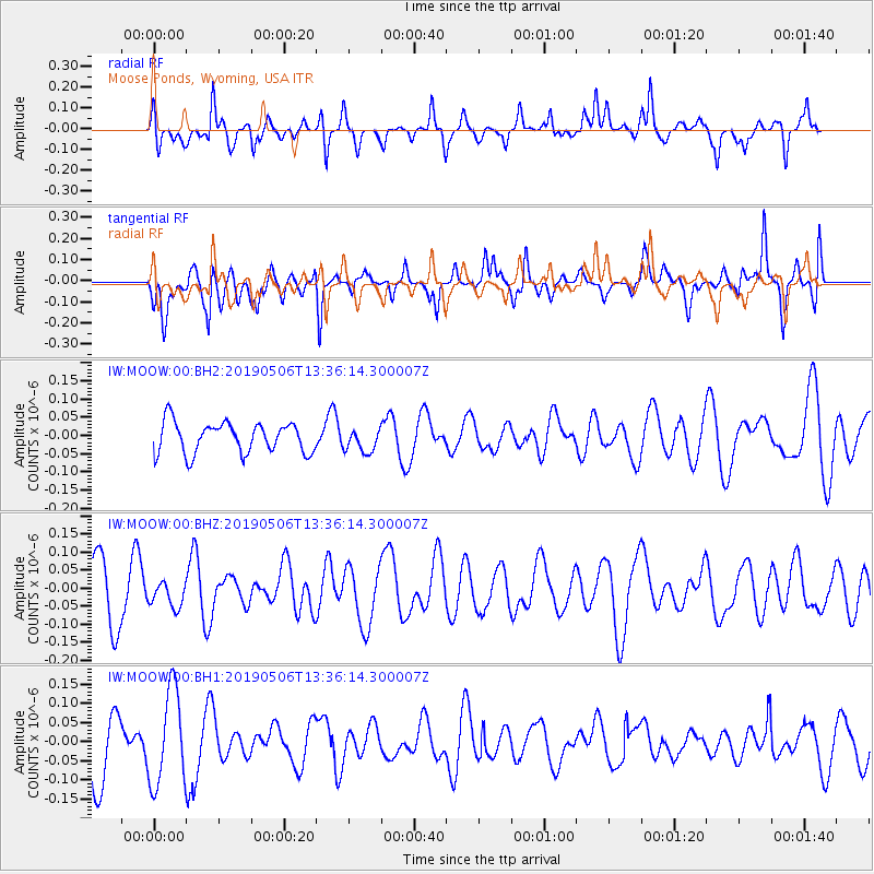
MOOW Moose Ponds, Wyoming, USA - Earthquake Result Viewer
*The percent match for this event was below the threshold and hence no stack was calculated.
| Earthquake location: |
North Of Ascension Island |
| Earthquake latitude/longitude: |
-3.2/-12.3 |
| Earthquake time(UTC): |
2019/05/06 (126) 13:23:08 GMT |
| Earthquake Depth: |
10 km |
| Earthquake Magnitude: |
5.4 Mww |
| Earthquake Catalog/Contributor: |
NEIC PDE/us |
|
| Network: |
IW Intermountain West |
| Station: |
MOOW Moose Ponds, Wyoming, USA |
| Lat/Lon: |
43.75 N/110.74 W |
| Elevation: |
2128 m |
|
| Distance: |
98.3 deg |
| Az: |
313.579 deg |
| Baz: |
86.475 deg |
| Ray Param: |
$rayparam |
*The percent match for this event was below the threshold and hence was not used in the summary stack. |
|
| Radial Match: |
57.198624 % |
| Radial Bump: |
356 |
| Transverse Match: |
50.491302 % |
| Transverse Bump: |
400 |
| SOD ConfigId: |
18252611 |
| Insert Time: |
2019-05-20 13:25:08.592 +0000 |
| GWidth: |
2.5 |
| Max Bumps: |
400 |
| Tol: |
0.001 |
|
Signal To Noise
| Channel | StoN | STA | LTA |
| IW:MOOW:00:BHZ:20190506T13:36:14.300007Z | 0.41661054 | 3.391701E-8 | 8.14118E-8 |
| IW:MOOW:00:BH1:20190506T13:36:14.300007Z | 1.9004313 | 1.2365993E-7 | 6.506941E-8 |
| IW:MOOW:00:BH2:20190506T13:36:14.300007Z | 0.752363 | 3.1747692E-8 | 4.2197307E-8 |
| Arrivals |
| Ps | |
| PpPs | |
| PsPs/PpSs | |


