You are here: Home > Network List > TA - USArray Transportable Network (new EarthScope stations) Stations List
> Station L15K Ungalak Mountain, AK, USA > Earthquake Result Viewer
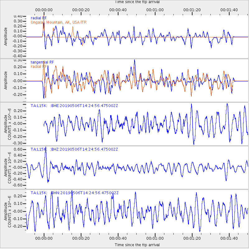
L15K Ungalak Mountain, AK, USA - Earthquake Result Viewer
*The percent match for this event was below the threshold and hence no stack was calculated.
| Earthquake location: |
Solomon Islands |
| Earthquake latitude/longitude: |
-6.2/154.8 |
| Earthquake time(UTC): |
2019/05/06 (126) 14:13:48 GMT |
| Earthquake Depth: |
59 km |
| Earthquake Magnitude: |
5.5 mb |
| Earthquake Catalog/Contributor: |
NEIC PDE/us |
|
| Network: |
TA USArray Transportable Network (new EarthScope stations) |
| Station: |
L15K Ungalak Mountain, AK, USA |
| Lat/Lon: |
61.68 N/161.49 W |
| Elevation: |
219 m |
|
| Distance: |
75.6 deg |
| Az: |
19.888 deg |
| Baz: |
225.167 deg |
| Ray Param: |
$rayparam |
*The percent match for this event was below the threshold and hence was not used in the summary stack. |
|
| Radial Match: |
64.04666 % |
| Radial Bump: |
400 |
| Transverse Match: |
51.085686 % |
| Transverse Bump: |
400 |
| SOD ConfigId: |
18252611 |
| Insert Time: |
2019-05-20 14:17:15.129 +0000 |
| GWidth: |
2.5 |
| Max Bumps: |
400 |
| Tol: |
0.001 |
|
Signal To Noise
| Channel | StoN | STA | LTA |
| TA:L15K: :BHZ:20190506T14:24:56.475002Z | 2.832966 | 3.2056747E-7 | 1.13156126E-7 |
| TA:L15K: :BHN:20190506T14:24:56.475002Z | 1.7786843 | 1.4809619E-7 | 8.326165E-8 |
| TA:L15K: :BHE:20190506T14:24:56.475002Z | 1.5710157 | 1.336772E-7 | 8.508967E-8 |
| Arrivals |
| Ps | |
| PpPs | |
| PsPs/PpSs | |


