You are here: Home > Network List > 1E - GSC-BCOGC Induced Seismicity Study Stations List
> Station MONT2 Z > Earthquake Result Viewer
MONT2 Z - Earthquake Result Viewer
| Earthquake location: |
Eastern New Guinea Reg., P.N.G. |
| Earthquake latitude/longitude: |
-7.0/146.4 |
| Earthquake time(UTC): |
2019/05/06 (126) 21:19:37 GMT |
| Earthquake Depth: |
146 km |
| Earthquake Magnitude: |
7.1 mww |
| Earthquake Catalog/Contributor: |
NEIC PDE/us |
|
| Network: |
1E GSC-BCOGC Induced Seismicity Study |
| Station: |
MONT2 Z |
| Lat/Lon: |
56.02 N/120.05 W |
| Elevation: |
642 m |
|
| Distance: |
97.7 deg |
| Az: |
34.439 deg |
| Baz: |
268.987 deg |
| Ray Param: |
0.04000777 |
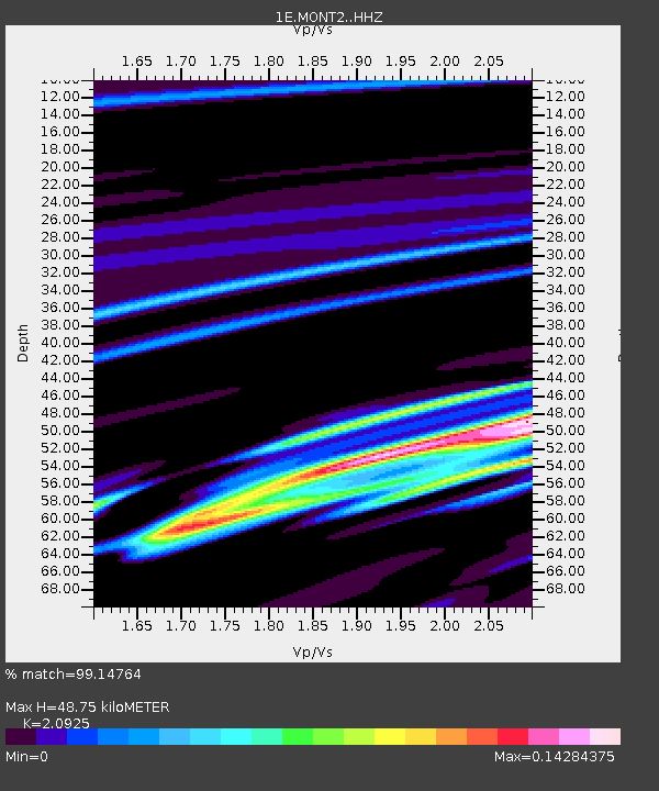
| Estimated Moho Depth: |
48.75 km |
| Estimated Crust Vp/Vs: |
2.09 |
| Assumed Crust Vp: |
6.291 km/s |
| Estimated Crust Vs: |
3.006 km/s |
| Estimated Crust Poisson's Ratio: |
0.35 |
|
| Radial Match: |
99.14764 % |
| Radial Bump: |
85 |
| Transverse Match: |
99.14764 % |
| Transverse Bump: |
85 |
| SOD ConfigId: |
18369291 |
| Insert Time: |
2019-05-20 21:19:47.349 +0000 |
| GWidth: |
2.5 |
| Max Bumps: |
400 |
| Tol: |
0.001 |
|

Signal To Noise
| Channel | StoN | STA | LTA |
| 1E:MONT2: :HHZ:20190506T21:32:24.68997Z | 8.48796 | 1.3844168E-6 | 1.6310359E-7 |
| $trig.getChannelId() | $trig.getValue() | $trig.getSTA() | $trig.getLTA() |
| 1E:MONT2: :HHE:20190506T21:32:24.68997Z | 11.743622 | 1.9115996E-6 | 1.6277768E-7 |
| Arrivals |
| Ps | 8.6 SECOND |
| PpPs | 24 SECOND |
| PsPs/PpSs | 32 SECOND |


