You are here: Home > Network List > US - United States National Seismic Network Stations List
> Station HDIL Hopedale, Illinois, USA > Earthquake Result Viewer
HDIL Hopedale, Illinois, USA - Earthquake Result Viewer
*The percent match for this event was below the threshold and hence no stack was calculated.
| Earthquake location: |
Unimak Island Region, Alaska |
| Earthquake latitude/longitude: |
53.6/-163.3 |
| Earthquake time(UTC): |
2016/10/27 (301) 11:53:18 GMT |
| Earthquake Depth: |
17 km |
| Earthquake Magnitude: |
5.8 MWP, 5.8 MI |
| Earthquake Catalog/Contributor: |
NEIC PDE/NEIC COMCAT |
|
| Network: |
US United States National Seismic Network |
| Station: |
HDIL Hopedale, Illinois, USA |
| Lat/Lon: |
40.56 N/89.29 W |
| Elevation: |
219 m |
|
| Distance: |
49.8 deg |
| Az: |
73.5 deg |
| Baz: |
311.444 deg |
| Ray Param: |
$rayparam |
*The percent match for this event was below the threshold and hence was not used in the summary stack. |
|
| Radial Match: |
70.100266 % |
| Radial Bump: |
400 |
| Transverse Match: |
58.031376 % |
| Transverse Bump: |
400 |
| SOD ConfigId: |
1815711 |
| Insert Time: |
2016-11-10 12:01:37.272 +0000 |
| GWidth: |
2.5 |
| Max Bumps: |
400 |
| Tol: |
0.001 |
|
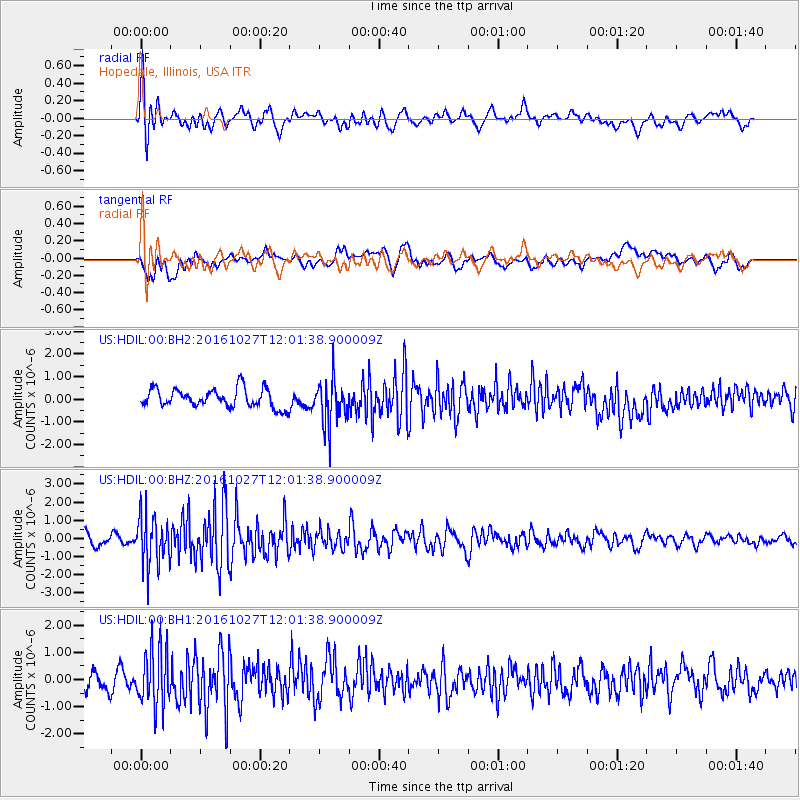
Signal To Noise
| Channel | StoN | STA | LTA |
| US:HDIL:00:BHZ:20161027T12:01:38.900009Z | 3.8526952 | 1.3666478E-6 | 3.5472513E-7 |
| US:HDIL:00:BH1:20161027T12:01:38.900009Z | 3.1056023 | 1.0464163E-6 | 3.369447E-7 |
| US:HDIL:00:BH2:20161027T12:01:38.900009Z | 2.3759854 | 9.703176E-7 | 4.0838535E-7 |
| Arrivals |
| Ps | |
| PpPs | |
| PsPs/PpSs | |


