You are here: Home > Network List > US - United States National Seismic Network Stations List
> Station MSO Missoula, Montana, USA > Earthquake Result Viewer
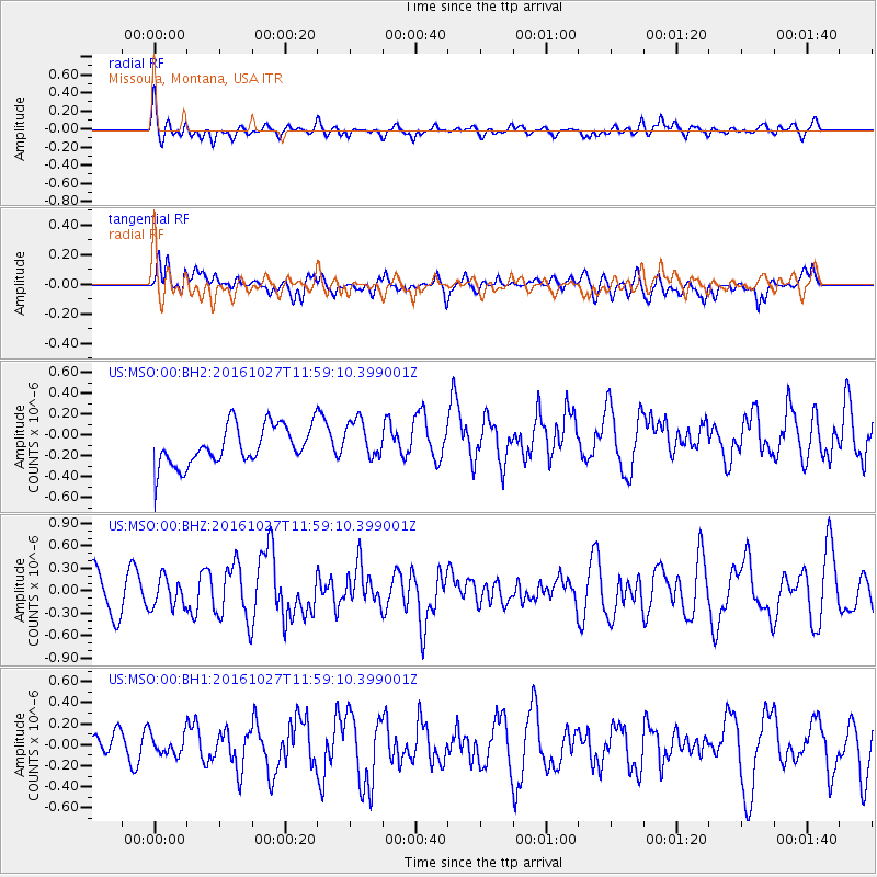
MSO Missoula, Montana, USA - Earthquake Result Viewer
*The percent match for this event was below the threshold and hence no stack was calculated.
| Earthquake location: |
Unimak Island Region, Alaska |
| Earthquake latitude/longitude: |
53.6/-163.3 |
| Earthquake time(UTC): |
2016/10/27 (301) 11:53:18 GMT |
| Earthquake Depth: |
17 km |
| Earthquake Magnitude: |
5.8 MWP, 5.8 MI |
| Earthquake Catalog/Contributor: |
NEIC PDE/NEIC COMCAT |
|
| Network: |
US United States National Seismic Network |
| Station: |
MSO Missoula, Montana, USA |
| Lat/Lon: |
46.83 N/113.94 W |
| Elevation: |
1264 m |
|
| Distance: |
31.7 deg |
| Az: |
81.947 deg |
| Baz: |
300.797 deg |
| Ray Param: |
$rayparam |
*The percent match for this event was below the threshold and hence was not used in the summary stack. |
|
| Radial Match: |
46.97877 % |
| Radial Bump: |
400 |
| Transverse Match: |
51.30068 % |
| Transverse Bump: |
400 |
| SOD ConfigId: |
1815711 |
| Insert Time: |
2016-11-10 12:02:03.234 +0000 |
| GWidth: |
2.5 |
| Max Bumps: |
400 |
| Tol: |
0.001 |
|
Signal To Noise
| Channel | StoN | STA | LTA |
| US:MSO:00:BHZ:20161027T11:59:10.399001Z | 0.58472985 | 1.9542875E-7 | 3.3422057E-7 |
| US:MSO:00:BH1:20161027T11:59:10.399001Z | 0.64308846 | 1.02333125E-7 | 1.591276E-7 |
| US:MSO:00:BH2:20161027T11:59:10.399001Z | 1.0034823 | 1.8805729E-7 | 1.874047E-7 |
| Arrivals |
| Ps | |
| PpPs | |
| PsPs/PpSs | |


