You are here: Home > Network List > CN - Canadian National Seismograph Network Stations List
> Station RUBB Prince Rupert, BC, CA > Earthquake Result Viewer
RUBB Prince Rupert, BC, CA - Earthquake Result Viewer
| Earthquake location: |
Eastern New Guinea Reg., P.N.G. |
| Earthquake latitude/longitude: |
-7.0/146.4 |
| Earthquake time(UTC): |
2019/05/06 (126) 21:19:37 GMT |
| Earthquake Depth: |
146 km |
| Earthquake Magnitude: |
7.1 mww |
| Earthquake Catalog/Contributor: |
NEIC PDE/us |
|
| Network: |
CN Canadian National Seismograph Network |
| Station: |
RUBB Prince Rupert, BC, CA |
| Lat/Lon: |
54.33 N/130.25 W |
| Elevation: |
12 m |
|
| Distance: |
91.7 deg |
| Az: |
35.592 deg |
| Baz: |
260.525 deg |
| Ray Param: |
0.04150326 |
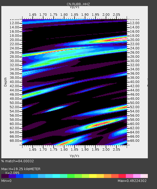
| Estimated Moho Depth: |
19.25 km |
| Estimated Crust Vp/Vs: |
2.10 |
| Assumed Crust Vp: |
6.545 km/s |
| Estimated Crust Vs: |
3.124 km/s |
| Estimated Crust Poisson's Ratio: |
0.35 |
|
| Radial Match: |
84.00032 % |
| Radial Bump: |
400 |
| Transverse Match: |
80.30068 % |
| Transverse Bump: |
400 |
| SOD ConfigId: |
18369291 |
| Insert Time: |
2019-05-20 21:22:05.277 +0000 |
| GWidth: |
2.5 |
| Max Bumps: |
400 |
| Tol: |
0.001 |
|

Signal To Noise
| Channel | StoN | STA | LTA |
| CN:RUBB: :HHZ:20190506T21:31:57.600004Z | 30.435827 | 3.8923026E-6 | 1.2788556E-7 |
| CN:RUBB: :HHN:20190506T21:31:57.600004Z | 1.1631707 | 2.0798117E-7 | 1.7880538E-7 |
| CN:RUBB: :HHE:20190506T21:31:57.600004Z | 9.103858 | 1.223212E-6 | 1.3436194E-7 |
| Arrivals |
| Ps | 3.3 SECOND |
| PpPs | 8.9 SECOND |
| PsPs/PpSs | 12 SECOND |


