You are here: Home > Network List > G - GEOSCOPE Stations List
> Station KIP Kipapa, Hawai, U.S.A. (Pacific Ocean) > Earthquake Result Viewer
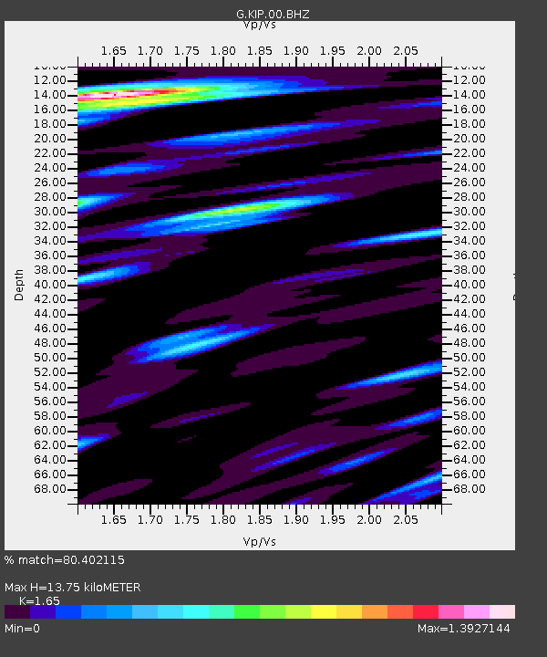
KIP Kipapa, Hawai, U.S.A. (Pacific Ocean) - Earthquake Result Viewer
| Earthquake location: |
Eastern New Guinea Reg., P.N.G. |
| Earthquake latitude/longitude: |
-7.0/146.4 |
| Earthquake time(UTC): |
2019/05/06 (126) 21:19:37 GMT |
| Earthquake Depth: |
146 km |
| Earthquake Magnitude: |
7.1 mww |
| Earthquake Catalog/Contributor: |
NEIC PDE/us |
|
| Network: |
G GEOSCOPE |
| Station: |
KIP Kipapa, Hawai, U.S.A. (Pacific Ocean) |
| Lat/Lon: |
21.42 N/158.01 W |
| Elevation: |
70 m |
|
| Distance: |
61.3 deg |
| Az: |
61.099 deg |
| Baz: |
248.865 deg |
| Ray Param: |
0.060510226 |
| Estimated Moho Depth: |
13.75 km |
| Estimated Crust Vp/Vs: |
1.65 |
| Assumed Crust Vp: |
4.24 km/s |
| Estimated Crust Vs: |
2.57 km/s |
| Estimated Crust Poisson's Ratio: |
0.21 |
|
| Radial Match: |
80.402115 % |
| Radial Bump: |
400 |
| Transverse Match: |
77.48637 % |
| Transverse Bump: |
400 |
| SOD ConfigId: |
18369291 |
| Insert Time: |
2019-05-20 21:22:17.164 +0000 |
| GWidth: |
2.5 |
| Max Bumps: |
400 |
| Tol: |
0.001 |
|

Signal To Noise
| Channel | StoN | STA | LTA |
| G:KIP:00:BHZ:20190506T21:29:07.519011Z | 4.3677473 | 2.2116117E-5 | 5.0635067E-6 |
| G:KIP:00:BH1:20190506T21:29:07.519011Z | 3.1152256 | 8.397397E-6 | 2.6955984E-6 |
| G:KIP:00:BH2:20190506T21:29:07.519011Z | 6.076396 | 1.51851855E-5 | 2.499045E-6 |
| Arrivals |
| Ps | 2.2 SECOND |
| PpPs | 8.4 SECOND |
| PsPs/PpSs | 11 SECOND |


