You are here: Home > Network List > TA - USArray Transportable Network (new EarthScope stations) Stations List
> Station M10A I.L. Ranch, Tuscararo, NV, USA > Earthquake Result Viewer
M10A I.L. Ranch, Tuscararo, NV, USA - Earthquake Result Viewer
| Earthquake location: |
South Of Fiji Islands |
| Earthquake latitude/longitude: |
-26.0/-177.5 |
| Earthquake time(UTC): |
2007/12/09 (343) 07:28:20 GMT |
| Earthquake Depth: |
152 km |
| Earthquake Magnitude: |
7.0 MB, 7.8 MW, 7.7 MW |
| Earthquake Catalog/Contributor: |
WHDF/NEIC |
|
| Network: |
TA USArray Transportable Network (new EarthScope stations) |
| Station: |
M10A I.L. Ranch, Tuscararo, NV, USA |
| Lat/Lon: |
41.52 N/116.54 W |
| Elevation: |
1687 m |
|
| Distance: |
87.7 deg |
| Az: |
41.081 deg |
| Baz: |
231.959 deg |
| Ray Param: |
0.04278537 |
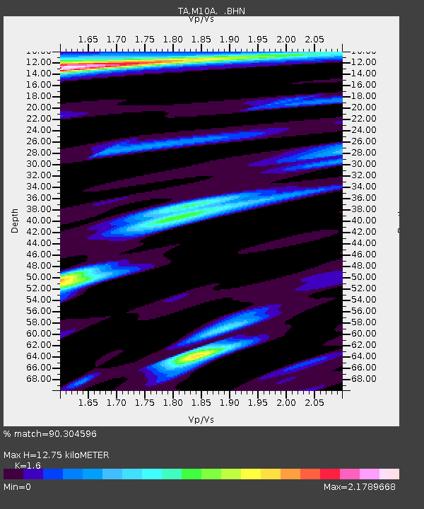
| Estimated Moho Depth: |
12.75 km |
| Estimated Crust Vp/Vs: |
1.60 |
| Assumed Crust Vp: |
6.276 km/s |
| Estimated Crust Vs: |
3.922 km/s |
| Estimated Crust Poisson's Ratio: |
0.18 |
|
| Radial Match: |
90.304596 % |
| Radial Bump: |
384 |
| Transverse Match: |
89.44927 % |
| Transverse Bump: |
400 |
| SOD ConfigId: |
2564 |
| Insert Time: |
2010-03-06 22:06:53.596 +0000 |
| GWidth: |
2.5 |
| Max Bumps: |
400 |
| Tol: |
0.001 |
|

Signal To Noise
| Channel | StoN | STA | LTA |
| TA:M10A: :BHN:20071209T07:40:21.049004Z | 0.65480024 | 1.9675076E-7 | 3.0047448E-7 |
| TA:M10A: :BHE:20071209T07:40:21.049004Z | 0.685318 | 3.860662E-7 | 5.6333874E-7 |
| TA:M10A: :BHZ:20071209T07:40:21.049004Z | 7.033797 | 1.4102052E-6 | 2.0048991E-7 |
| Arrivals |
| Ps | 1.2 SECOND |
| PpPs | 5.2 SECOND |
| PsPs/PpSs | 6.4 SECOND |


