You are here: Home > Network List > IU - Global Seismograph Network (GSN - IRIS/USGS) Stations List
> Station JOHN Johnston Island, USA > Earthquake Result Viewer
JOHN Johnston Island, USA - Earthquake Result Viewer

| Earthquake location: |
Eastern New Guinea Reg., P.N.G. |
| Earthquake latitude/longitude: |
-7.0/146.4 |
| Earthquake time(UTC): |
2019/05/06 (126) 21:19:37 GMT |
| Earthquake Depth: |
146 km |
| Earthquake Magnitude: |
7.1 mww |
| Earthquake Catalog/Contributor: |
NEIC PDE/us |
|
| Network: |
IU Global Seismograph Network (GSN - IRIS/USGS) |
| Station: |
JOHN Johnston Island, USA |
| Lat/Lon: |
16.73 N/169.53 W |
| Elevation: |
2.0 m |
|
| Distance: |
49.5 deg |
| Az: |
61.127 deg |
| Baz: |
245.126 deg |
| Ray Param: |
0.06816001 |
| Estimated Moho Depth: |
61.0 km |
| Estimated Crust Vp/Vs: |
2.10 |
| Assumed Crust Vp: |
4.24 km/s |
| Estimated Crust Vs: |
2.024 km/s |
| Estimated Crust Poisson's Ratio: |
0.35 |
|
| Radial Match: |
80.36221 % |
| Radial Bump: |
400 |
| Transverse Match: |
74.81017 % |
| Transverse Bump: |
400 |
| SOD ConfigId: |
18369291 |
| Insert Time: |
2019-05-20 21:22:43.612 +0000 |
| GWidth: |
2.5 |
| Max Bumps: |
400 |
| Tol: |
0.001 |
|
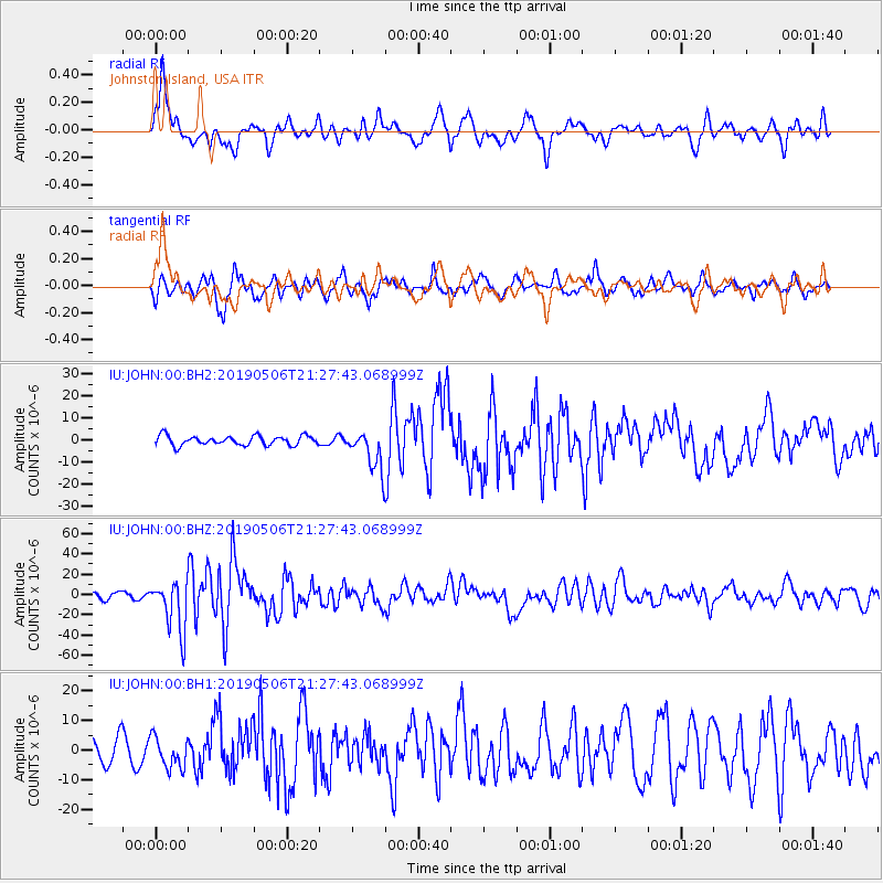
Signal To Noise
| Channel | StoN | STA | LTA |
| IU:JOHN:00:BHZ:20190506T21:27:43.068999Z | 6.3829775 | 2.5116318E-5 | 3.9348906E-6 |
| IU:JOHN:00:BH1:20190506T21:27:43.068999Z | 1.5097016 | 5.248463E-6 | 3.4764905E-6 |
| IU:JOHN:00:BH2:20190506T21:27:43.068999Z | 4.270454 | 9.081768E-6 | 2.1266517E-6 |
| Arrivals |
| Ps | 16 SECOND |
| PpPs | 44 SECOND |
| PsPs/PpSs | 60 SECOND |


