You are here: Home > Network List > JP - Japan Meteorological Agency Seismic Network Stations List
> Station JTM Aomori Tenma > Earthquake Result Viewer
JTM Aomori Tenma - Earthquake Result Viewer
| Earthquake location: |
Eastern New Guinea Reg., P.N.G. |
| Earthquake latitude/longitude: |
-7.0/146.4 |
| Earthquake time(UTC): |
2019/05/06 (126) 21:19:37 GMT |
| Earthquake Depth: |
146 km |
| Earthquake Magnitude: |
7.1 mww |
| Earthquake Catalog/Contributor: |
NEIC PDE/us |
|
| Network: |
JP Japan Meteorological Agency Seismic Network |
| Station: |
JTM Aomori Tenma |
| Lat/Lon: |
40.79 N/141.06 E |
| Elevation: |
130 m |
|
| Distance: |
47.8 deg |
| Az: |
354.48 deg |
| Baz: |
172.775 deg |
| Ray Param: |
0.06926096 |
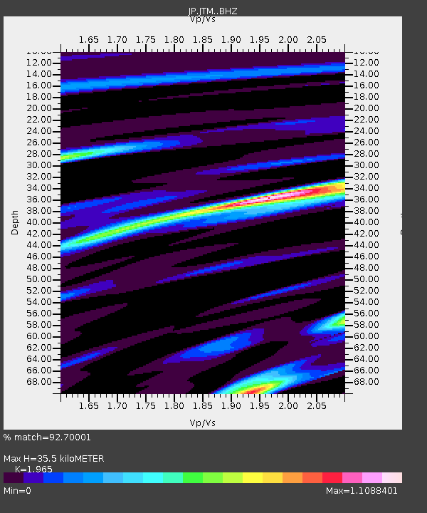
| Estimated Moho Depth: |
35.5 km |
| Estimated Crust Vp/Vs: |
1.97 |
| Assumed Crust Vp: |
6.468 km/s |
| Estimated Crust Vs: |
3.291 km/s |
| Estimated Crust Poisson's Ratio: |
0.33 |
|
| Radial Match: |
92.70001 % |
| Radial Bump: |
400 |
| Transverse Match: |
80.77738 % |
| Transverse Bump: |
400 |
| SOD ConfigId: |
18369291 |
| Insert Time: |
2019-05-20 21:22:58.862 +0000 |
| GWidth: |
2.5 |
| Max Bumps: |
400 |
| Tol: |
0.001 |
|

Signal To Noise
| Channel | StoN | STA | LTA |
| JP:JTM: :BHZ:20190506T21:27:29.999998Z | 43.95651 | 1.3520473E-5 | 3.075875E-7 |
| JP:JTM: :BHN:20190506T21:27:29.999998Z | 24.02435 | 7.0042965E-6 | 2.915499E-7 |
| JP:JTM: :BHE:20190506T21:27:29.999998Z | 8.766065 | 1.3274597E-6 | 1.5143165E-7 |
| Arrivals |
| Ps | 5.6 SECOND |
| PpPs | 15 SECOND |
| PsPs/PpSs | 21 SECOND |


