You are here: Home > Network List > TA - USArray Transportable Network (new EarthScope stations) Stations List
> Station M10A I.L. Ranch, Tuscararo, NV, USA > Earthquake Result Viewer
M10A I.L. Ranch, Tuscararo, NV, USA - Earthquake Result Viewer

| Earthquake location: |
Near Coast Of Peru |
| Earthquake latitude/longitude: |
-14.3/-76.1 |
| Earthquake time(UTC): |
2007/08/16 (228) 05:16:56 GMT |
| Earthquake Depth: |
23 km |
| Earthquake Magnitude: |
5.8 MB, 6.1 MS, 6.3 MW, 6.2 ML |
| Earthquake Catalog/Contributor: |
WHDF/NEIC |
|
| Network: |
TA USArray Transportable Network (new EarthScope stations) |
| Station: |
M10A I.L. Ranch, Tuscararo, NV, USA |
| Lat/Lon: |
41.52 N/116.54 W |
| Elevation: |
1687 m |
|
| Distance: |
66.9 deg |
| Az: |
328.045 deg |
| Baz: |
136.897 deg |
| Ray Param: |
0.057282183 |
| Estimated Moho Depth: |
26.25 km |
| Estimated Crust Vp/Vs: |
1.78 |
| Assumed Crust Vp: |
6.276 km/s |
| Estimated Crust Vs: |
3.531 km/s |
| Estimated Crust Poisson's Ratio: |
0.27 |
|
| Radial Match: |
84.04104 % |
| Radial Bump: |
400 |
| Transverse Match: |
76.20103 % |
| Transverse Bump: |
400 |
| SOD ConfigId: |
2564 |
| Insert Time: |
2010-03-06 22:07:17.992 +0000 |
| GWidth: |
2.5 |
| Max Bumps: |
400 |
| Tol: |
0.001 |
|
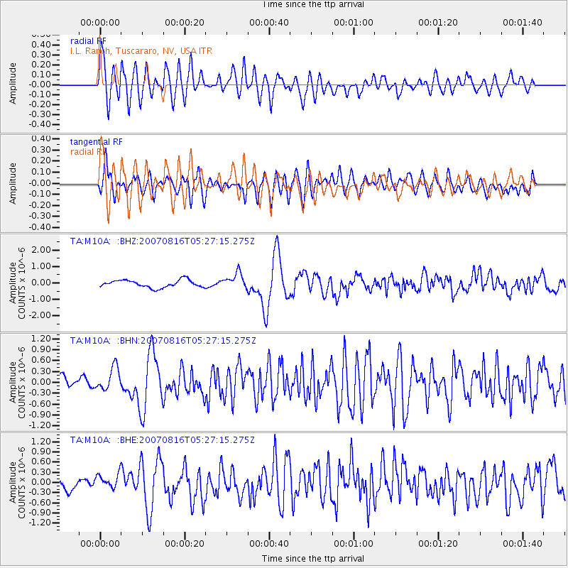
Signal To Noise
| Channel | StoN | STA | LTA |
| TA:M10A: :BHN:20070816T05:27:15.275Z | 1.8707875 | 3.282647E-7 | 1.7546873E-7 |
| TA:M10A: :BHE:20070816T05:27:15.275Z | 1.6908801 | 2.5107823E-7 | 1.4848969E-7 |
| TA:M10A: :BHZ:20070816T05:27:15.275Z | 2.2146878 | 4.961857E-7 | 2.2404319E-7 |
| Arrivals |
| Ps | 3.4 SECOND |
| PpPs | 11 SECOND |
| PsPs/PpSs | 15 SECOND |


