You are here: Home > Network List > MM - Myanmar National Seismic Network Stations List
> Station NGU Ngaung U, Myanmar > Earthquake Result Viewer
NGU Ngaung U, Myanmar - Earthquake Result Viewer
| Earthquake location: |
Eastern New Guinea Reg., P.N.G. |
| Earthquake latitude/longitude: |
-7.0/146.4 |
| Earthquake time(UTC): |
2019/05/06 (126) 21:19:37 GMT |
| Earthquake Depth: |
146 km |
| Earthquake Magnitude: |
7.1 mww |
| Earthquake Catalog/Contributor: |
NEIC PDE/us |
|
| Network: |
MM Myanmar National Seismic Network |
| Station: |
NGU Ngaung U, Myanmar |
| Lat/Lon: |
21.21 N/94.92 E |
| Elevation: |
70 m |
|
| Distance: |
57.8 deg |
| Az: |
300.306 deg |
| Baz: |
113.294 deg |
| Ray Param: |
0.06280129 |
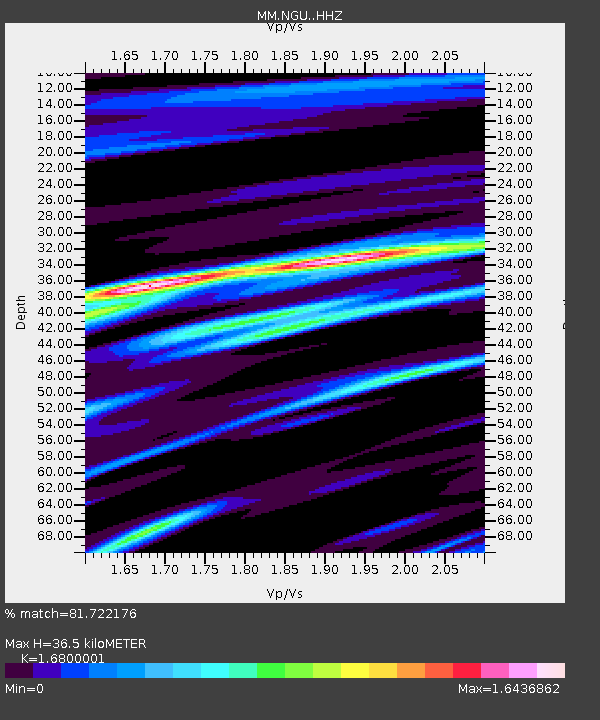
| Estimated Moho Depth: |
36.5 km |
| Estimated Crust Vp/Vs: |
1.68 |
| Assumed Crust Vp: |
6.036 km/s |
| Estimated Crust Vs: |
3.593 km/s |
| Estimated Crust Poisson's Ratio: |
0.23 |
|
| Radial Match: |
81.722176 % |
| Radial Bump: |
400 |
| Transverse Match: |
76.4263 % |
| Transverse Bump: |
400 |
| SOD ConfigId: |
18369291 |
| Insert Time: |
2019-05-20 21:23:19.341 +0000 |
| GWidth: |
2.5 |
| Max Bumps: |
400 |
| Tol: |
0.001 |
|

Signal To Noise
| Channel | StoN | STA | LTA |
| MM:NGU: :HHZ:20190506T21:28:43.329985Z | 58.00722 | 7.387188E-6 | 1.2734945E-7 |
| MM:NGU: :HHN:20190506T21:28:43.329985Z | 4.2279344 | 8.33741E-7 | 1.9719819E-7 |
| MM:NGU: :HHE:20190506T21:28:43.329985Z | 6.0974092 | 1.1824525E-6 | 1.9392704E-7 |
| Arrivals |
| Ps | 4.3 SECOND |
| PpPs | 15 SECOND |
| PsPs/PpSs | 20 SECOND |


