You are here: Home > Network List > TA - USArray Transportable Network (new EarthScope stations) Stations List
> Station E27K Coleen River, AK, USA > Earthquake Result Viewer
E27K Coleen River, AK, USA - Earthquake Result Viewer
| Earthquake location: |
Eastern New Guinea Reg., P.N.G. |
| Earthquake latitude/longitude: |
-7.0/146.4 |
| Earthquake time(UTC): |
2019/05/06 (126) 21:19:37 GMT |
| Earthquake Depth: |
146 km |
| Earthquake Magnitude: |
7.1 mww |
| Earthquake Catalog/Contributor: |
NEIC PDE/us |
|
| Network: |
TA USArray Transportable Network (new EarthScope stations) |
| Station: |
E27K Coleen River, AK, USA |
| Lat/Lon: |
68.19 N/141.60 W |
| Elevation: |
654 m |
|
| Distance: |
89.8 deg |
| Az: |
20.816 deg |
| Baz: |
250.714 deg |
| Ray Param: |
0.041686464 |
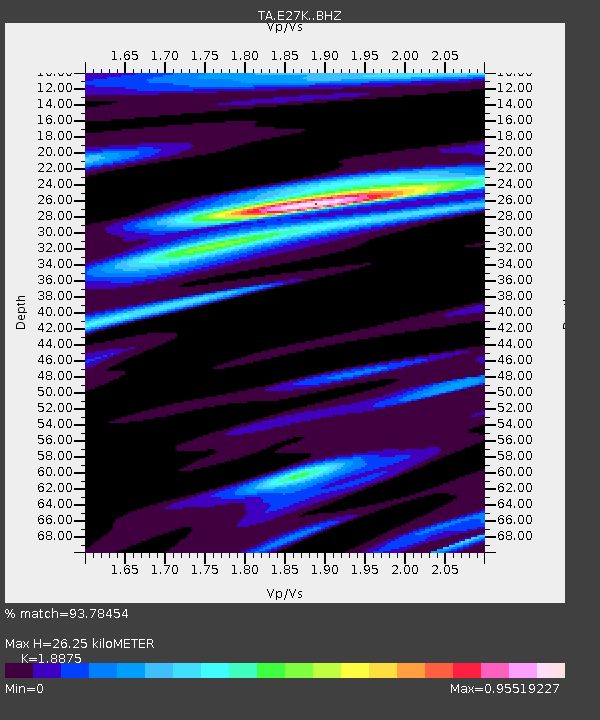
| Estimated Moho Depth: |
26.25 km |
| Estimated Crust Vp/Vs: |
1.89 |
| Assumed Crust Vp: |
6.522 km/s |
| Estimated Crust Vs: |
3.455 km/s |
| Estimated Crust Poisson's Ratio: |
0.30 |
|
| Radial Match: |
93.78454 % |
| Radial Bump: |
400 |
| Transverse Match: |
91.07299 % |
| Transverse Bump: |
400 |
| SOD ConfigId: |
18369291 |
| Insert Time: |
2019-05-20 21:24:10.821 +0000 |
| GWidth: |
2.5 |
| Max Bumps: |
400 |
| Tol: |
0.001 |
|

Signal To Noise
| Channel | StoN | STA | LTA |
| TA:E27K: :BHZ:20190506T21:31:48.875029Z | 72.523964 | 8.652966E-6 | 1.1931182E-7 |
| TA:E27K: :BHN:20190506T21:31:48.875029Z | 6.844767 | 5.5918036E-7 | 8.169457E-8 |
| TA:E27K: :BHE:20190506T21:31:48.875029Z | 39.291924 | 2.5413756E-6 | 6.467934E-8 |
| Arrivals |
| Ps | 3.6 SECOND |
| PpPs | 11 SECOND |
| PsPs/PpSs | 15 SECOND |


