You are here: Home > Network List > TA - USArray Transportable Network (new EarthScope stations) Stations List
> Station G15K Niukluk, AK, USA > Earthquake Result Viewer
G15K Niukluk, AK, USA - Earthquake Result Viewer
| Earthquake location: |
Eastern New Guinea Reg., P.N.G. |
| Earthquake latitude/longitude: |
-7.0/146.4 |
| Earthquake time(UTC): |
2019/05/06 (126) 21:19:37 GMT |
| Earthquake Depth: |
146 km |
| Earthquake Magnitude: |
7.1 mww |
| Earthquake Catalog/Contributor: |
NEIC PDE/us |
|
| Network: |
TA USArray Transportable Network (new EarthScope stations) |
| Station: |
G15K Niukluk, AK, USA |
| Lat/Lon: |
64.99 N/164.04 W |
| Elevation: |
249 m |
|
| Distance: |
80.5 deg |
| Az: |
19.132 deg |
| Baz: |
229.948 deg |
| Ray Param: |
0.047881797 |
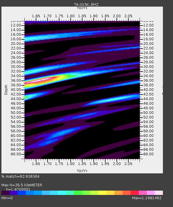
| Estimated Moho Depth: |
35.5 km |
| Estimated Crust Vp/Vs: |
1.67 |
| Assumed Crust Vp: |
6.276 km/s |
| Estimated Crust Vs: |
3.758 km/s |
| Estimated Crust Poisson's Ratio: |
0.22 |
|
| Radial Match: |
92.939384 % |
| Radial Bump: |
400 |
| Transverse Match: |
89.23353 % |
| Transverse Bump: |
400 |
| SOD ConfigId: |
18369291 |
| Insert Time: |
2019-05-20 21:24:20.760 +0000 |
| GWidth: |
2.5 |
| Max Bumps: |
400 |
| Tol: |
0.001 |
|

Signal To Noise
| Channel | StoN | STA | LTA |
| TA:G15K: :BHZ:20190506T21:31:02.800017Z | 40.30999 | 9.224262E-6 | 2.2883314E-7 |
| TA:G15K: :BHN:20190506T21:31:02.800017Z | 12.370693 | 1.6545962E-6 | 1.3375129E-7 |
| TA:G15K: :BHE:20190506T21:31:02.800017Z | 14.6118765 | 2.4768037E-6 | 1.695062E-7 |
| Arrivals |
| Ps | 3.9 SECOND |
| PpPs | 15 SECOND |
| PsPs/PpSs | 19 SECOND |


