You are here: Home > Network List > TA - USArray Transportable Network (new EarthScope stations) Stations List
> Station G23K Bananza Creek, AK, USA > Earthquake Result Viewer
G23K Bananza Creek, AK, USA - Earthquake Result Viewer
| Earthquake location: |
Eastern New Guinea Reg., P.N.G. |
| Earthquake latitude/longitude: |
-7.0/146.4 |
| Earthquake time(UTC): |
2019/05/06 (126) 21:19:37 GMT |
| Earthquake Depth: |
146 km |
| Earthquake Magnitude: |
7.1 mww |
| Earthquake Catalog/Contributor: |
NEIC PDE/us |
|
| Network: |
TA USArray Transportable Network (new EarthScope stations) |
| Station: |
G23K Bananza Creek, AK, USA |
| Lat/Lon: |
66.71 N/150.02 W |
| Elevation: |
746 m |
|
| Distance: |
86.3 deg |
| Az: |
20.897 deg |
| Baz: |
242.937 deg |
| Ray Param: |
0.043852918 |
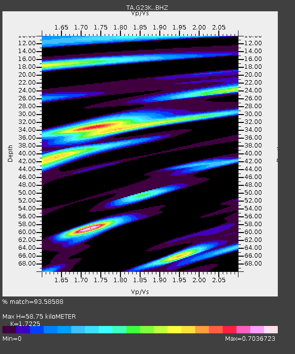
| Estimated Moho Depth: |
58.75 km |
| Estimated Crust Vp/Vs: |
1.72 |
| Assumed Crust Vp: |
6.577 km/s |
| Estimated Crust Vs: |
3.818 km/s |
| Estimated Crust Poisson's Ratio: |
0.25 |
|
| Radial Match: |
93.58588 % |
| Radial Bump: |
400 |
| Transverse Match: |
86.98247 % |
| Transverse Bump: |
400 |
| SOD ConfigId: |
18369291 |
| Insert Time: |
2019-05-20 21:24:24.733 +0000 |
| GWidth: |
2.5 |
| Max Bumps: |
400 |
| Tol: |
0.001 |
|
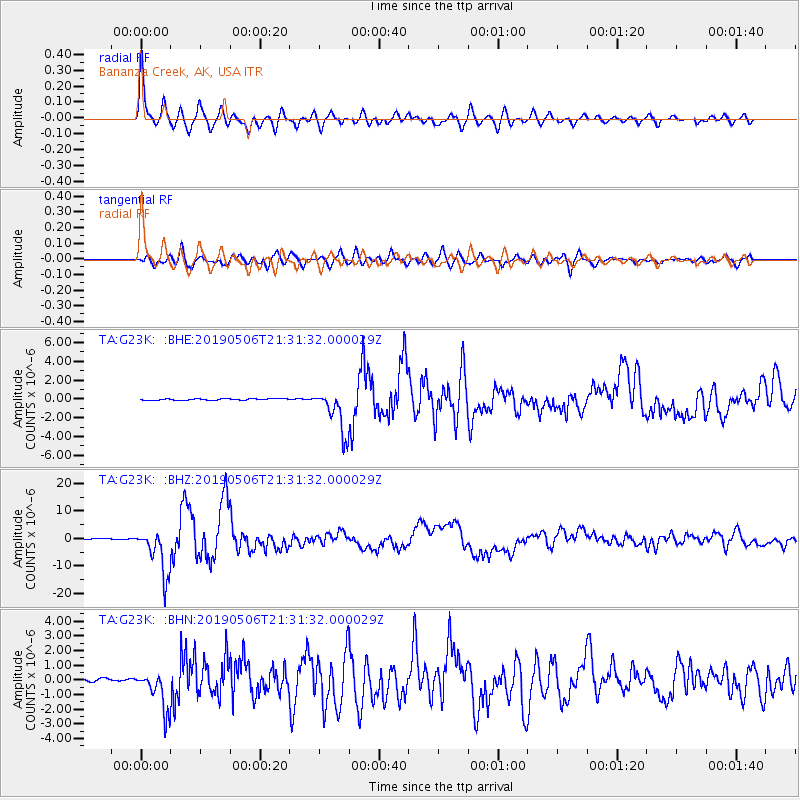
Signal To Noise
| Channel | StoN | STA | LTA |
| TA:G23K: :BHZ:20190506T21:31:32.000029Z | 66.060104 | 8.449924E-6 | 1.2791266E-7 |
| TA:G23K: :BHN:20190506T21:31:32.000029Z | 17.263557 | 1.3356974E-6 | 7.7370935E-8 |
| TA:G23K: :BHE:20190506T21:31:32.000029Z | 28.339294 | 2.3228108E-6 | 8.196431E-8 |
| Arrivals |
| Ps | 6.6 SECOND |
| PpPs | 24 SECOND |
| PsPs/PpSs | 30 SECOND |


