You are here: Home > Network List > TA - USArray Transportable Network (new EarthScope stations) Stations List
> Station G31M Satah River, YT, CAN > Earthquake Result Viewer
G31M Satah River, YT, CAN - Earthquake Result Viewer
| Earthquake location: |
Eastern New Guinea Reg., P.N.G. |
| Earthquake latitude/longitude: |
-7.0/146.4 |
| Earthquake time(UTC): |
2019/05/06 (126) 21:19:37 GMT |
| Earthquake Depth: |
146 km |
| Earthquake Magnitude: |
7.1 mww |
| Earthquake Catalog/Contributor: |
NEIC PDE/us |
|
| Network: |
TA USArray Transportable Network (new EarthScope stations) |
| Station: |
G31M Satah River, YT, CAN |
| Lat/Lon: |
66.92 N/134.27 W |
| Elevation: |
61 m |
|
| Distance: |
92.2 deg |
| Az: |
22.806 deg |
| Baz: |
257.443 deg |
| Ray Param: |
0.04142501 |
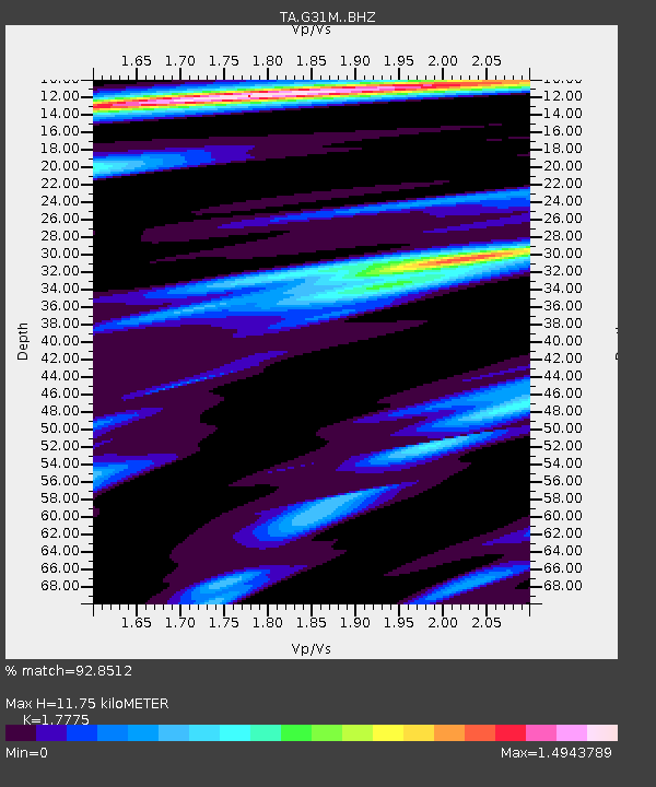
| Estimated Moho Depth: |
11.75 km |
| Estimated Crust Vp/Vs: |
1.78 |
| Assumed Crust Vp: |
6.171 km/s |
| Estimated Crust Vs: |
3.472 km/s |
| Estimated Crust Poisson's Ratio: |
0.27 |
|
| Radial Match: |
92.8512 % |
| Radial Bump: |
400 |
| Transverse Match: |
78.816185 % |
| Transverse Bump: |
400 |
| SOD ConfigId: |
18369291 |
| Insert Time: |
2019-05-20 21:24:28.310 +0000 |
| GWidth: |
2.5 |
| Max Bumps: |
400 |
| Tol: |
0.001 |
|
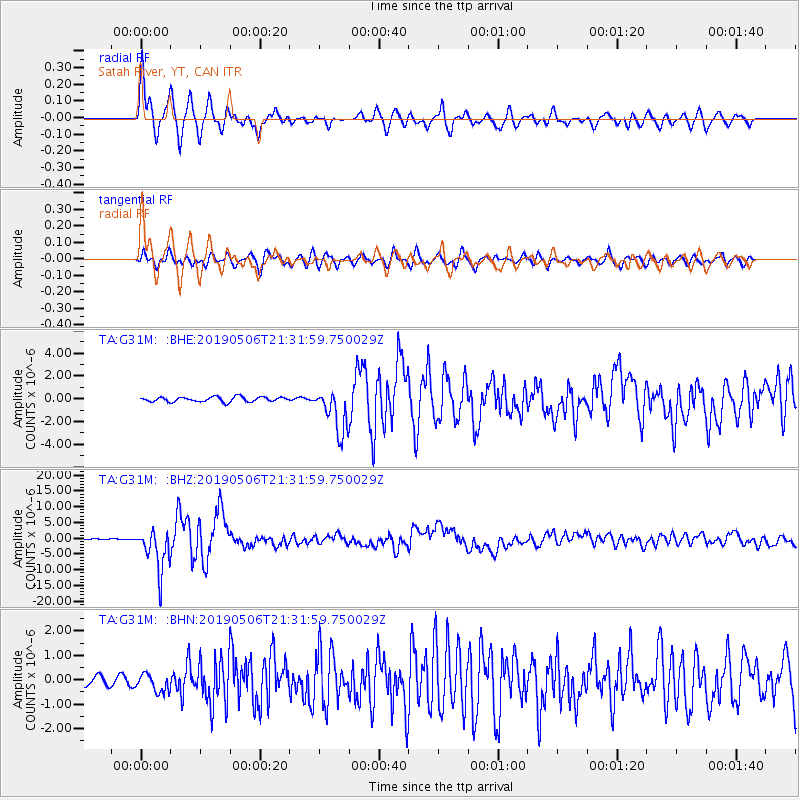
Signal To Noise
| Channel | StoN | STA | LTA |
| TA:G31M: :BHZ:20190506T21:31:59.750029Z | 52.81211 | 6.726744E-6 | 1.2737124E-7 |
| TA:G31M: :BHN:20190506T21:31:59.750029Z | 1.9697576 | 3.7582333E-7 | 1.9079674E-7 |
| TA:G31M: :BHE:20190506T21:31:59.750029Z | 9.034359 | 1.9293086E-6 | 2.1355237E-7 |
| Arrivals |
| Ps | 1.5 SECOND |
| PpPs | 5.2 SECOND |
| PsPs/PpSs | 6.7 SECOND |


