You are here: Home > Network List > TA - USArray Transportable Network (new EarthScope stations) Stations List
> Station I26K Coal Creek Mining Camp, AK, USA > Earthquake Result Viewer
I26K Coal Creek Mining Camp, AK, USA - Earthquake Result Viewer
| Earthquake location: |
Eastern New Guinea Reg., P.N.G. |
| Earthquake latitude/longitude: |
-7.0/146.4 |
| Earthquake time(UTC): |
2019/05/06 (126) 21:19:37 GMT |
| Earthquake Depth: |
146 km |
| Earthquake Magnitude: |
7.1 mww |
| Earthquake Catalog/Contributor: |
NEIC PDE/us |
|
| Network: |
TA USArray Transportable Network (new EarthScope stations) |
| Station: |
I26K Coal Creek Mining Camp, AK, USA |
| Lat/Lon: |
65.31 N/143.15 W |
| Elevation: |
338 m |
|
| Distance: |
88.3 deg |
| Az: |
23.323 deg |
| Baz: |
249.324 deg |
| Ray Param: |
0.042397134 |
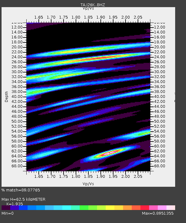
| Estimated Moho Depth: |
62.5 km |
| Estimated Crust Vp/Vs: |
1.93 |
| Assumed Crust Vp: |
6.566 km/s |
| Estimated Crust Vs: |
3.393 km/s |
| Estimated Crust Poisson's Ratio: |
0.32 |
|
| Radial Match: |
89.07765 % |
| Radial Bump: |
400 |
| Transverse Match: |
82.42258 % |
| Transverse Bump: |
400 |
| SOD ConfigId: |
18369291 |
| Insert Time: |
2019-05-20 21:24:38.423 +0000 |
| GWidth: |
2.5 |
| Max Bumps: |
400 |
| Tol: |
0.001 |
|

Signal To Noise
| Channel | StoN | STA | LTA |
| TA:I26K: :BHZ:20190506T21:31:41.57498Z | 51.026 | 7.2304047E-6 | 1.417004E-7 |
| TA:I26K: :BHN:20190506T21:31:41.57498Z | 13.197816 | 1.6377662E-6 | 1.2409373E-7 |
| TA:I26K: :BHE:20190506T21:31:41.57498Z | 28.86897 | 2.820576E-6 | 9.770269E-8 |
| Arrivals |
| Ps | 9.1 SECOND |
| PpPs | 27 SECOND |
| PsPs/PpSs | 36 SECOND |


