You are here: Home > Network List > TA - USArray Transportable Network (new EarthScope stations) Stations List
> Station M10A I.L. Ranch, Tuscararo, NV, USA > Earthquake Result Viewer
M10A I.L. Ranch, Tuscararo, NV, USA - Earthquake Result Viewer

| Earthquake location: |
New Britain Region, P.N.G. |
| Earthquake latitude/longitude: |
-5.9/151.0 |
| Earthquake time(UTC): |
2006/10/17 (290) 01:25:12 GMT |
| Earthquake Depth: |
32 km |
| Earthquake Magnitude: |
6.4 MB, 6.9 MS, 6.7 MW, 6.6 MW |
| Earthquake Catalog/Contributor: |
WHDF/NEIC |
|
| Network: |
TA USArray Transportable Network (new EarthScope stations) |
| Station: |
M10A I.L. Ranch, Tuscararo, NV, USA |
| Lat/Lon: |
41.52 N/116.54 W |
| Elevation: |
1687 m |
|
| Distance: |
95.7 deg |
| Az: |
48.933 deg |
| Baz: |
267.234 deg |
| Ray Param: |
0.040695913 |
| Estimated Moho Depth: |
64.25 km |
| Estimated Crust Vp/Vs: |
1.81 |
| Assumed Crust Vp: |
6.276 km/s |
| Estimated Crust Vs: |
3.477 km/s |
| Estimated Crust Poisson's Ratio: |
0.28 |
|
| Radial Match: |
83.98864 % |
| Radial Bump: |
400 |
| Transverse Match: |
82.349655 % |
| Transverse Bump: |
400 |
| SOD ConfigId: |
2665 |
| Insert Time: |
2010-03-06 22:08:05.056 +0000 |
| GWidth: |
2.5 |
| Max Bumps: |
400 |
| Tol: |
0.001 |
|
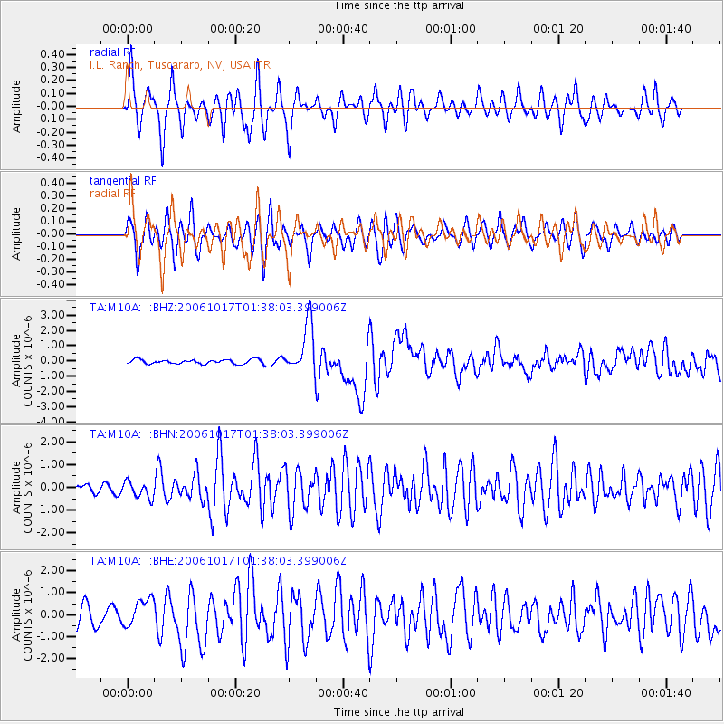
Signal To Noise
| Channel | StoN | STA | LTA |
| TA:M10A: :BHN:20061017T01:38:03.399006Z | 1.545607 | 3.5871219E-7 | 2.3208499E-7 |
| TA:M10A: :BHE:20061017T01:38:03.399006Z | 1.5130428 | 6.427399E-7 | 4.2479954E-7 |
| TA:M10A: :BHZ:20061017T01:38:03.399006Z | 12.209501 | 1.6844942E-6 | 1.3796586E-7 |
| Arrivals |
| Ps | 8.4 SECOND |
| PpPs | 28 SECOND |
| PsPs/PpSs | 37 SECOND |


