You are here: Home > Network List > TA - USArray Transportable Network (new EarthScope stations) Stations List
> Station M13K Dall Lake, AK, USA > Earthquake Result Viewer
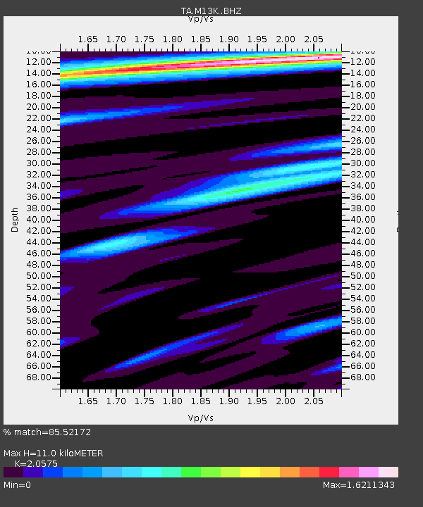
M13K Dall Lake, AK, USA - Earthquake Result Viewer
| Earthquake location: |
Eastern New Guinea Reg., P.N.G. |
| Earthquake latitude/longitude: |
-7.0/146.4 |
| Earthquake time(UTC): |
2019/05/06 (126) 21:19:37 GMT |
| Earthquake Depth: |
146 km |
| Earthquake Magnitude: |
7.1 mww |
| Earthquake Catalog/Contributor: |
NEIC PDE/us |
|
| Network: |
TA USArray Transportable Network (new EarthScope stations) |
| Station: |
M13K Dall Lake, AK, USA |
| Lat/Lon: |
60.41 N/163.35 W |
| Elevation: |
9.0 m |
|
| Distance: |
77.8 deg |
| Az: |
22.955 deg |
| Baz: |
231.277 deg |
| Ray Param: |
0.049689982 |
| Estimated Moho Depth: |
11.0 km |
| Estimated Crust Vp/Vs: |
2.06 |
| Assumed Crust Vp: |
6.1 km/s |
| Estimated Crust Vs: |
2.965 km/s |
| Estimated Crust Poisson's Ratio: |
0.35 |
|
| Radial Match: |
85.52172 % |
| Radial Bump: |
400 |
| Transverse Match: |
81.67963 % |
| Transverse Bump: |
400 |
| SOD ConfigId: |
18369291 |
| Insert Time: |
2019-05-20 21:24:56.505 +0000 |
| GWidth: |
2.5 |
| Max Bumps: |
400 |
| Tol: |
0.001 |
|

Signal To Noise
| Channel | StoN | STA | LTA |
| TA:M13K: :BHZ:20190506T21:30:48.32498Z | 22.380184 | 1.6309024E-5 | 7.287261E-7 |
| TA:M13K: :BHN:20190506T21:30:48.32498Z | 1.2050304 | 1.1241542E-6 | 9.328845E-7 |
| TA:M13K: :BHE:20190506T21:30:48.32498Z | 2.750387 | 1.464228E-6 | 5.3237164E-7 |
| Arrivals |
| Ps | 2.0 SECOND |
| PpPs | 5.4 SECOND |
| PsPs/PpSs | 7.3 SECOND |


