You are here: Home > Network List > TA - USArray Transportable Network (new EarthScope stations) Stations List
> Station M10A I.L. Ranch, Tuscararo, NV, USA > Earthquake Result Viewer
M10A I.L. Ranch, Tuscararo, NV, USA - Earthquake Result Viewer
| Earthquake location: |
Kuril Islands |
| Earthquake latitude/longitude: |
46.5/153.2 |
| Earthquake time(UTC): |
2006/10/01 (274) 09:06:02 GMT |
| Earthquake Depth: |
19 km |
| Earthquake Magnitude: |
6.1 MB, 6.4 MS, 6.6 MW, 6.5 MW |
| Earthquake Catalog/Contributor: |
WHDF/NEIC |
|
| Network: |
TA USArray Transportable Network (new EarthScope stations) |
| Station: |
M10A I.L. Ranch, Tuscararo, NV, USA |
| Lat/Lon: |
41.52 N/116.54 W |
| Elevation: |
1687 m |
|
| Distance: |
61.6 deg |
| Az: |
58.59 deg |
| Baz: |
308.228 deg |
| Ray Param: |
0.06073689 |
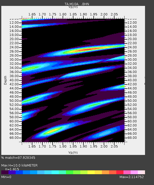
| Estimated Moho Depth: |
10.0 km |
| Estimated Crust Vp/Vs: |
1.62 |
| Assumed Crust Vp: |
6.276 km/s |
| Estimated Crust Vs: |
3.886 km/s |
| Estimated Crust Poisson's Ratio: |
0.19 |
|
| Radial Match: |
87.928345 % |
| Radial Bump: |
400 |
| Transverse Match: |
85.06266 % |
| Transverse Bump: |
400 |
| SOD ConfigId: |
2665 |
| Insert Time: |
2010-03-06 22:08:09.566 +0000 |
| GWidth: |
2.5 |
| Max Bumps: |
400 |
| Tol: |
0.001 |
|

Signal To Noise
| Channel | StoN | STA | LTA |
| TA:M10A: :BHN:20061001T09:15:47.549004Z | 1.1923876 | 3.400034E-7 | 2.8514506E-7 |
| TA:M10A: :BHE:20061001T09:15:47.549004Z | 0.8171535 | 3.1025763E-7 | 3.7968098E-7 |
| TA:M10A: :BHZ:20061001T09:15:47.549004Z | 7.3433547 | 6.66532E-7 | 9.076668E-8 |
| Arrivals |
| Ps | 1.0 SECOND |
| PpPs | 4.0 SECOND |
| PsPs/PpSs | 5.0 SECOND |


