You are here: Home > Network List > TA - USArray Transportable Network (new EarthScope stations) Stations List
> Station M18K Stony River, AK, USA > Earthquake Result Viewer
M18K Stony River, AK, USA - Earthquake Result Viewer
| Earthquake location: |
Eastern New Guinea Reg., P.N.G. |
| Earthquake latitude/longitude: |
-7.0/146.4 |
| Earthquake time(UTC): |
2019/05/06 (126) 21:19:37 GMT |
| Earthquake Depth: |
146 km |
| Earthquake Magnitude: |
7.1 mww |
| Earthquake Catalog/Contributor: |
NEIC PDE/us |
|
| Network: |
TA USArray Transportable Network (new EarthScope stations) |
| Station: |
M18K Stony River, AK, USA |
| Lat/Lon: |
61.49 N/155.82 W |
| Elevation: |
289 m |
|
| Distance: |
81.5 deg |
| Az: |
24.218 deg |
| Baz: |
238.076 deg |
| Ray Param: |
0.047222972 |
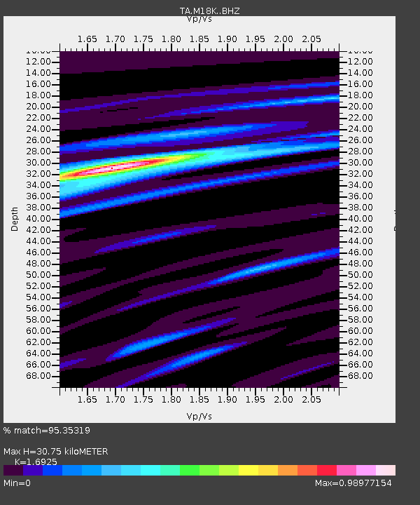
| Estimated Moho Depth: |
30.75 km |
| Estimated Crust Vp/Vs: |
1.69 |
| Assumed Crust Vp: |
6.566 km/s |
| Estimated Crust Vs: |
3.88 km/s |
| Estimated Crust Poisson's Ratio: |
0.23 |
|
| Radial Match: |
95.35319 % |
| Radial Bump: |
400 |
| Transverse Match: |
92.45251 % |
| Transverse Bump: |
400 |
| SOD ConfigId: |
18369291 |
| Insert Time: |
2019-05-20 21:25:00.381 +0000 |
| GWidth: |
2.5 |
| Max Bumps: |
400 |
| Tol: |
0.001 |
|

Signal To Noise
| Channel | StoN | STA | LTA |
| TA:M18K: :BHZ:20190506T21:31:07.774992Z | 57.274372 | 1.1232202E-5 | 1.9611218E-7 |
| TA:M18K: :BHN:20190506T21:31:07.774992Z | 11.934603 | 1.5567757E-6 | 1.3044219E-7 |
| TA:M18K: :BHE:20190506T21:31:07.774992Z | 18.811903 | 3.0147694E-6 | 1.6025861E-7 |
| Arrivals |
| Ps | 3.3 SECOND |
| PpPs | 12 SECOND |
| PsPs/PpSs | 16 SECOND |


