You are here: Home > Network List > TA - USArray Transportable Network (new EarthScope stations) Stations List
> Station M10A I.L. Ranch, Tuscararo, NV, USA > Earthquake Result Viewer
M10A I.L. Ranch, Tuscararo, NV, USA - Earthquake Result Viewer
| Earthquake location: |
Samoa Islands Region |
| Earthquake latitude/longitude: |
-16.6/-172.0 |
| Earthquake time(UTC): |
2006/09/28 (271) 06:22:09 GMT |
| Earthquake Depth: |
28 km |
| Earthquake Magnitude: |
6.5 MB, 6.6 MS, 6.9 MW, 6.7 MW |
| Earthquake Catalog/Contributor: |
WHDF/NEIC |
|
| Network: |
TA USArray Transportable Network (new EarthScope stations) |
| Station: |
M10A I.L. Ranch, Tuscararo, NV, USA |
| Lat/Lon: |
41.52 N/116.54 W |
| Elevation: |
1687 m |
|
| Distance: |
77.3 deg |
| Az: |
39.376 deg |
| Baz: |
234.107 deg |
| Ray Param: |
0.05040548 |
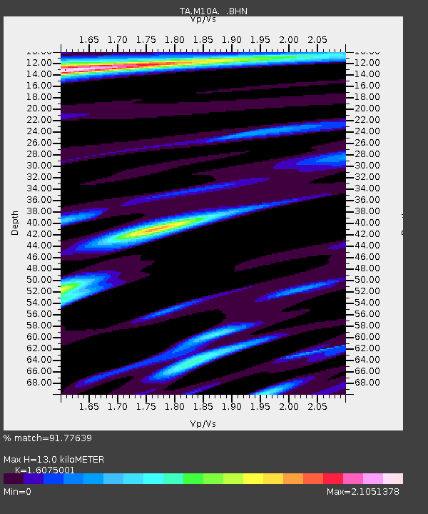
| Estimated Moho Depth: |
13.0 km |
| Estimated Crust Vp/Vs: |
1.61 |
| Assumed Crust Vp: |
6.276 km/s |
| Estimated Crust Vs: |
3.904 km/s |
| Estimated Crust Poisson's Ratio: |
0.18 |
|
| Radial Match: |
91.77639 % |
| Radial Bump: |
400 |
| Transverse Match: |
87.776825 % |
| Transverse Bump: |
400 |
| SOD ConfigId: |
2665 |
| Insert Time: |
2010-03-06 22:08:10.927 +0000 |
| GWidth: |
2.5 |
| Max Bumps: |
400 |
| Tol: |
0.001 |
|

Signal To Noise
| Channel | StoN | STA | LTA |
| TA:M10A: :BHN:20060928T06:33:30.198018Z | 8.736085 | 9.779465E-7 | 1.11943336E-7 |
| TA:M10A: :BHE:20060928T06:33:30.198018Z | 14.590012 | 2.1862058E-6 | 1.4984263E-7 |
| TA:M10A: :BHZ:20060928T06:33:30.198018Z | 64.27276 | 5.54914E-6 | 8.633736E-8 |
| Arrivals |
| Ps | 1.3 SECOND |
| PpPs | 5.2 SECOND |
| PsPs/PpSs | 6.5 SECOND |


