You are here: Home > Network List > TA - USArray Transportable Network (new EarthScope stations) Stations List
> Station Q20K Shuyak Island, AK, USA > Earthquake Result Viewer
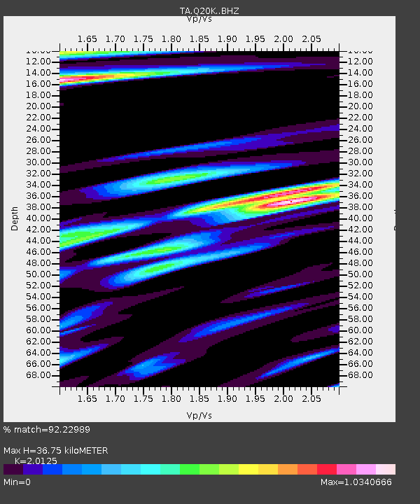
Q20K Shuyak Island, AK, USA - Earthquake Result Viewer
| Earthquake location: |
Eastern New Guinea Reg., P.N.G. |
| Earthquake latitude/longitude: |
-7.0/146.4 |
| Earthquake time(UTC): |
2019/05/06 (126) 21:19:37 GMT |
| Earthquake Depth: |
146 km |
| Earthquake Magnitude: |
7.1 mww |
| Earthquake Catalog/Contributor: |
NEIC PDE/us |
|
| Network: |
TA USArray Transportable Network (new EarthScope stations) |
| Station: |
Q20K Shuyak Island, AK, USA |
| Lat/Lon: |
58.61 N/152.39 W |
| Elevation: |
180 m |
|
| Distance: |
81.5 deg |
| Az: |
27.618 deg |
| Baz: |
241.548 deg |
| Ray Param: |
0.04719882 |
| Estimated Moho Depth: |
36.75 km |
| Estimated Crust Vp/Vs: |
2.01 |
| Assumed Crust Vp: |
5.989 km/s |
| Estimated Crust Vs: |
2.976 km/s |
| Estimated Crust Poisson's Ratio: |
0.34 |
|
| Radial Match: |
92.22989 % |
| Radial Bump: |
400 |
| Transverse Match: |
89.65168 % |
| Transverse Bump: |
400 |
| SOD ConfigId: |
18369291 |
| Insert Time: |
2019-05-20 21:25:25.789 +0000 |
| GWidth: |
2.5 |
| Max Bumps: |
400 |
| Tol: |
0.001 |
|

Signal To Noise
| Channel | StoN | STA | LTA |
| TA:Q20K: :BHZ:20190506T21:31:07.94998Z | 26.63861 | 1.2062226E-5 | 4.528099E-7 |
| TA:Q20K: :BHN:20190506T21:31:07.94998Z | 4.767378 | 2.0055372E-6 | 4.206793E-7 |
| TA:Q20K: :BHE:20190506T21:31:07.94998Z | 9.938908 | 3.9253196E-6 | 3.9494478E-7 |
| Arrivals |
| Ps | 6.3 SECOND |
| PpPs | 18 SECOND |
| PsPs/PpSs | 24 SECOND |


