You are here: Home > Network List > TA - USArray Transportable Network (new EarthScope stations) Stations List
> Station R16K Pilot Point, AK, USA > Earthquake Result Viewer
R16K Pilot Point, AK, USA - Earthquake Result Viewer
| Earthquake location: |
Eastern New Guinea Reg., P.N.G. |
| Earthquake latitude/longitude: |
-7.0/146.4 |
| Earthquake time(UTC): |
2019/05/06 (126) 21:19:37 GMT |
| Earthquake Depth: |
146 km |
| Earthquake Magnitude: |
7.1 mww |
| Earthquake Catalog/Contributor: |
NEIC PDE/us |
|
| Network: |
TA USArray Transportable Network (new EarthScope stations) |
| Station: |
R16K Pilot Point, AK, USA |
| Lat/Lon: |
57.57 N/157.57 W |
| Elevation: |
38 m |
|
| Distance: |
78.6 deg |
| Az: |
27.105 deg |
| Baz: |
237.069 deg |
| Ray Param: |
0.04918187 |
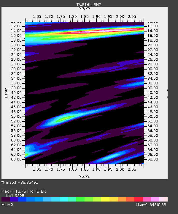
| Estimated Moho Depth: |
13.75 km |
| Estimated Crust Vp/Vs: |
1.93 |
| Assumed Crust Vp: |
6.1 km/s |
| Estimated Crust Vs: |
3.157 km/s |
| Estimated Crust Poisson's Ratio: |
0.32 |
|
| Radial Match: |
88.85491 % |
| Radial Bump: |
400 |
| Transverse Match: |
85.2285 % |
| Transverse Bump: |
400 |
| SOD ConfigId: |
18369291 |
| Insert Time: |
2019-05-20 21:25:26.860 +0000 |
| GWidth: |
2.5 |
| Max Bumps: |
400 |
| Tol: |
0.001 |
|

Signal To Noise
| Channel | StoN | STA | LTA |
| TA:R16K: :BHZ:20190506T21:30:52.475004Z | 34.09255 | 3.293389E-5 | 9.660143E-7 |
| TA:R16K: :BHN:20190506T21:30:52.475004Z | 4.1937776 | 4.0692616E-6 | 9.703094E-7 |
| TA:R16K: :BHE:20190506T21:30:52.475004Z | 4.6699634 | 4.574865E-6 | 9.796363E-7 |
| Arrivals |
| Ps | 2.2 SECOND |
| PpPs | 6.5 SECOND |
| PsPs/PpSs | 8.6 SECOND |


