You are here: Home > Network List > TA - USArray Transportable Network (new EarthScope stations) Stations List
> Station M10A I.L. Ranch, Tuscararo, NV, USA > Earthquake Result Viewer
M10A I.L. Ranch, Tuscararo, NV, USA - Earthquake Result Viewer
| Earthquake location: |
Tonga Islands |
| Earthquake latitude/longitude: |
-20.6/-173.9 |
| Earthquake time(UTC): |
2006/05/17 (137) 03:06:16 GMT |
| Earthquake Depth: |
10 km |
| Earthquake Magnitude: |
5.8 MB, 5.8 MS, 6.0 MW, 5.8 MW |
| Earthquake Catalog/Contributor: |
WHDF/NEIC |
|
| Network: |
TA USArray Transportable Network (new EarthScope stations) |
| Station: |
M10A I.L. Ranch, Tuscararo, NV, USA |
| Lat/Lon: |
41.52 N/116.54 W |
| Elevation: |
1687 m |
|
| Distance: |
81.5 deg |
| Az: |
39.767 deg |
| Baz: |
232.927 deg |
| Ray Param: |
0.04752776 |
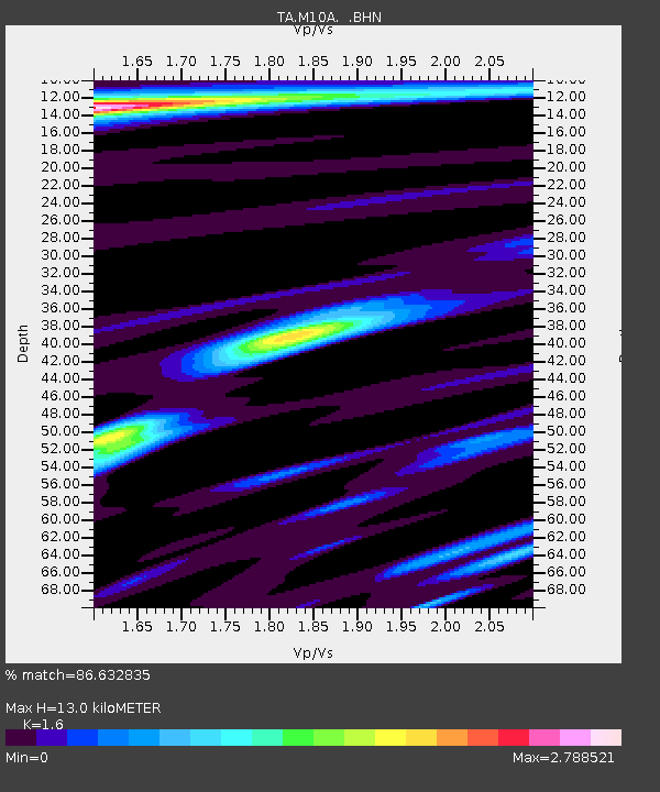
| Estimated Moho Depth: |
13.0 km |
| Estimated Crust Vp/Vs: |
1.60 |
| Assumed Crust Vp: |
6.276 km/s |
| Estimated Crust Vs: |
3.922 km/s |
| Estimated Crust Poisson's Ratio: |
0.18 |
|
| Radial Match: |
86.632835 % |
| Radial Bump: |
400 |
| Transverse Match: |
80.11199 % |
| Transverse Bump: |
363 |
| SOD ConfigId: |
2669 |
| Insert Time: |
2010-03-06 22:08:31.947 +0000 |
| GWidth: |
2.5 |
| Max Bumps: |
400 |
| Tol: |
0.001 |
|

Signal To Noise
| Channel | StoN | STA | LTA |
| TA:M10A: :BHN:20060517T03:18:02.299019Z | 1.3277135 | 3.0487783E-7 | 2.2962622E-7 |
| TA:M10A: :BHE:20060517T03:18:02.299019Z | 2.0614486 | 2.5755443E-7 | 1.2493857E-7 |
| TA:M10A: :BHZ:20060517T03:18:02.299019Z | 6.666869 | 6.3004944E-7 | 9.450454E-8 |
| Arrivals |
| Ps | 1.3 SECOND |
| PpPs | 5.2 SECOND |
| PsPs/PpSs | 6.5 SECOND |


