You are here: Home > Network List > US - United States National Seismic Network Stations List
> Station HAWA Hanford, Washington, USA > Earthquake Result Viewer
HAWA Hanford, Washington, USA - Earthquake Result Viewer

| Earthquake location: |
Eastern New Guinea Reg., P.N.G. |
| Earthquake latitude/longitude: |
-7.0/146.4 |
| Earthquake time(UTC): |
2019/05/06 (126) 21:19:37 GMT |
| Earthquake Depth: |
146 km |
| Earthquake Magnitude: |
7.1 mww |
| Earthquake Catalog/Contributor: |
NEIC PDE/us |
|
| Network: |
US United States National Seismic Network |
| Station: |
HAWA Hanford, Washington, USA |
| Lat/Lon: |
46.39 N/119.53 W |
| Elevation: |
364 m |
|
| Distance: |
97.8 deg |
| Az: |
44.174 deg |
| Baz: |
268.075 deg |
| Ray Param: |
0.03998339 |
| Estimated Moho Depth: |
37.75 km |
| Estimated Crust Vp/Vs: |
1.65 |
| Assumed Crust Vp: |
6.419 km/s |
| Estimated Crust Vs: |
3.885 km/s |
| Estimated Crust Poisson's Ratio: |
0.21 |
|
| Radial Match: |
93.12172 % |
| Radial Bump: |
400 |
| Transverse Match: |
79.25603 % |
| Transverse Bump: |
400 |
| SOD ConfigId: |
18369291 |
| Insert Time: |
2019-05-20 21:25:55.766 +0000 |
| GWidth: |
2.5 |
| Max Bumps: |
400 |
| Tol: |
0.001 |
|
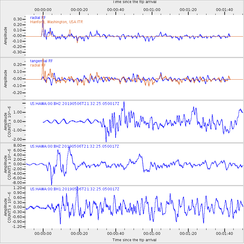
Signal To Noise
| Channel | StoN | STA | LTA |
| US:HAWA:00:BHZ:20190506T21:32:25.050017Z | 9.671073 | 2.496952E-6 | 2.581877E-7 |
| US:HAWA:00:BH1:20190506T21:32:25.050017Z | 0.9545466 | 7.309554E-8 | 7.657619E-8 |
| US:HAWA:00:BH2:20190506T21:32:25.050017Z | 4.836818 | 6.0657095E-7 | 1.2540701E-7 |
| Arrivals |
| Ps | 3.9 SECOND |
| PpPs | 15 SECOND |
| PsPs/PpSs | 19 SECOND |


