You are here: Home > Network List > UW - Pacific Northwest Regional Seismic Network Stations List
> Station KREP White Salmon, WA, USA > Earthquake Result Viewer
KREP White Salmon, WA, USA - Earthquake Result Viewer
| Earthquake location: |
Eastern New Guinea Reg., P.N.G. |
| Earthquake latitude/longitude: |
-7.0/146.4 |
| Earthquake time(UTC): |
2019/05/06 (126) 21:19:37 GMT |
| Earthquake Depth: |
146 km |
| Earthquake Magnitude: |
7.1 mww |
| Earthquake Catalog/Contributor: |
NEIC PDE/us |
|
| Network: |
UW Pacific Northwest Regional Seismic Network |
| Station: |
KREP White Salmon, WA, USA |
| Lat/Lon: |
45.89 N/121.46 W |
| Elevation: |
472 m |
|
| Distance: |
96.4 deg |
| Az: |
44.622 deg |
| Baz: |
266.634 deg |
| Ray Param: |
0.0403998 |
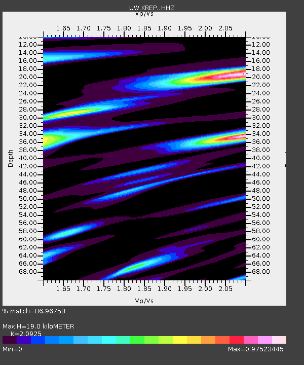
| Estimated Moho Depth: |
19.0 km |
| Estimated Crust Vp/Vs: |
2.09 |
| Assumed Crust Vp: |
6.597 km/s |
| Estimated Crust Vs: |
3.153 km/s |
| Estimated Crust Poisson's Ratio: |
0.35 |
|
| Radial Match: |
86.96758 % |
| Radial Bump: |
388 |
| Transverse Match: |
76.28211 % |
| Transverse Bump: |
400 |
| SOD ConfigId: |
18369291 |
| Insert Time: |
2019-05-20 21:26:08.337 +0000 |
| GWidth: |
2.5 |
| Max Bumps: |
400 |
| Tol: |
0.001 |
|

Signal To Noise
| Channel | StoN | STA | LTA |
| UW:KREP: :HHZ:20190506T21:32:18.95999Z | 15.786552 | 2.8782654E-6 | 1.8232387E-7 |
| UW:KREP: :HHN:20190506T21:32:18.95999Z | 1.7402122 | 3.6614477E-7 | 2.1040236E-7 |
| UW:KREP: :HHE:20190506T21:32:18.95999Z | 2.9675176 | 5.686132E-7 | 1.916124E-7 |
| Arrivals |
| Ps | 3.2 SECOND |
| PpPs | 8.8 SECOND |
| PsPs/PpSs | 12 SECOND |


