You are here: Home > Network List > UW - Pacific Northwest Regional Seismic Network Stations List
> Station LTY Liberty (broad-band) > Earthquake Result Viewer
LTY Liberty (broad-band) - Earthquake Result Viewer
| Earthquake location: |
Eastern New Guinea Reg., P.N.G. |
| Earthquake latitude/longitude: |
-7.0/146.4 |
| Earthquake time(UTC): |
2019/05/06 (126) 21:19:37 GMT |
| Earthquake Depth: |
146 km |
| Earthquake Magnitude: |
7.1 mww |
| Earthquake Catalog/Contributor: |
NEIC PDE/us |
|
| Network: |
UW Pacific Northwest Regional Seismic Network |
| Station: |
LTY Liberty (broad-band) |
| Lat/Lon: |
47.26 N/120.66 W |
| Elevation: |
970 m |
|
| Distance: |
97.0 deg |
| Az: |
43.272 deg |
| Baz: |
267.368 deg |
| Ray Param: |
0.04021363 |
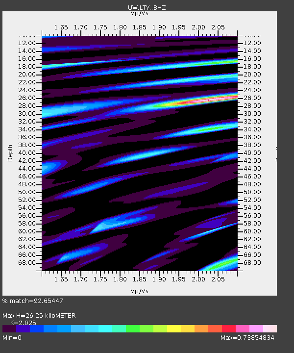
| Estimated Moho Depth: |
26.25 km |
| Estimated Crust Vp/Vs: |
2.03 |
| Assumed Crust Vp: |
6.597 km/s |
| Estimated Crust Vs: |
3.258 km/s |
| Estimated Crust Poisson's Ratio: |
0.34 |
|
| Radial Match: |
92.65447 % |
| Radial Bump: |
400 |
| Transverse Match: |
92.11162 % |
| Transverse Bump: |
400 |
| SOD ConfigId: |
18369291 |
| Insert Time: |
2019-05-20 21:26:10.213 +0000 |
| GWidth: |
2.5 |
| Max Bumps: |
400 |
| Tol: |
0.001 |
|
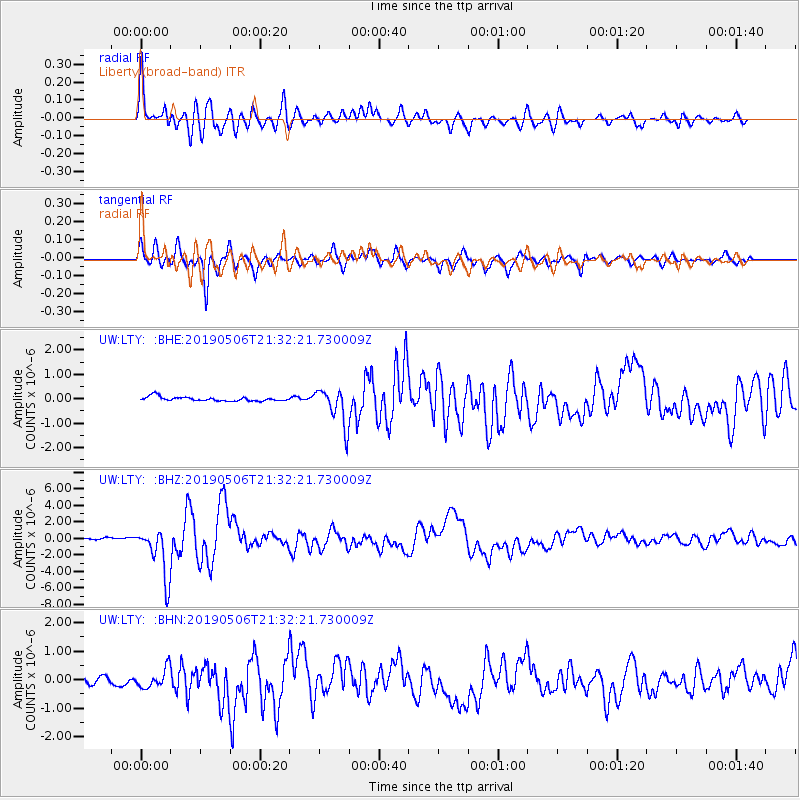
Signal To Noise
| Channel | StoN | STA | LTA |
| UW:LTY: :BHZ:20190506T21:32:21.730009Z | 28.035902 | 3.0432523E-6 | 1.085484E-7 |
| UW:LTY: :BHN:20190506T21:32:21.730009Z | 2.9030902 | 3.3953006E-7 | 1.169547E-7 |
| UW:LTY: :BHE:20190506T21:32:21.730009Z | 8.882907 | 7.5687586E-7 | 8.520588E-8 |
| Arrivals |
| Ps | 4.2 SECOND |
| PpPs | 12 SECOND |
| PsPs/PpSs | 16 SECOND |


