You are here: Home > Network List > IU - Global Seismograph Network (GSN - IRIS/USGS) Stations List
> Station PMG Port Moresby, New Guinea > Earthquake Result Viewer
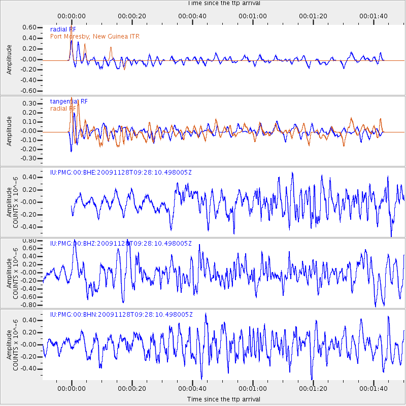
PMG Port Moresby, New Guinea - Earthquake Result Viewer
*The percent match for this event was below the threshold and hence no stack was calculated.
| Earthquake location: |
Kermadec Islands, New Zealand |
| Earthquake latitude/longitude: |
-29.2/-177.0 |
| Earthquake time(UTC): |
2009/11/28 (332) 09:21:17 GMT |
| Earthquake Depth: |
28 km |
| Earthquake Magnitude: |
5.8 MB, 5.8 MS, 6.0 MW, 5.9 MW |
| Earthquake Catalog/Contributor: |
WHDF/NEIC |
|
| Network: |
IU Global Seismograph Network (GSN - IRIS/USGS) |
| Station: |
PMG Port Moresby, New Guinea |
| Lat/Lon: |
9.40 S/147.16 E |
| Elevation: |
90 m |
|
| Distance: |
38.9 deg |
| Az: |
293.124 deg |
| Baz: |
125.437 deg |
| Ray Param: |
$rayparam |
*The percent match for this event was below the threshold and hence was not used in the summary stack. |
|
| Radial Match: |
60.09168 % |
| Radial Bump: |
400 |
| Transverse Match: |
52.424774 % |
| Transverse Bump: |
400 |
| SOD ConfigId: |
1 |
| Insert Time: |
2010-02-19 01:17:37.433 +0000 |
| GWidth: |
2.5 |
| Max Bumps: |
400 |
| Tol: |
0.001 |
|
Signal To Noise
| Channel | StoN | STA | LTA |
| IU:PMG:00:BHZ:20091128T09:28:10.498005Z | 3.2615864 | 3.4565178E-7 | 1.05976575E-7 |
| IU:PMG:00:BHN:20091128T09:28:10.498005Z | 1.0412194 | 1.11168994E-7 | 1.0676809E-7 |
| IU:PMG:00:BHE:20091128T09:28:10.498005Z | 1.7707592 | 1.8461003E-7 | 1.0425473E-7 |
| Arrivals |
| Ps | |
| PpPs | |
| PsPs/PpSs | |


