You are here: Home > Network List > TA - USArray Transportable Network (new EarthScope stations) Stations List
> Station B14A Marquette Ranch, East Glacier, MT, USA > Earthquake Result Viewer
B14A Marquette Ranch, East Glacier, MT, USA - Earthquake Result Viewer
| Earthquake location: |
Fiji Islands Region |
| Earthquake latitude/longitude: |
-17.3/-177.3 |
| Earthquake time(UTC): |
2008/07/19 (201) 22:39:52 GMT |
| Earthquake Depth: |
391 km |
| Earthquake Magnitude: |
5.9 MB, 6.4 MW, 6.4 MW |
| Earthquake Catalog/Contributor: |
WHDF/NEIC |
|
| Network: |
TA USArray Transportable Network (new EarthScope stations) |
| Station: |
B14A Marquette Ranch, East Glacier, MT, USA |
| Lat/Lon: |
48.36 N/113.27 W |
| Elevation: |
1529 m |
|
| Distance: |
86.7 deg |
| Az: |
36.916 deg |
| Baz: |
239.34 deg |
| Ray Param: |
0.04286958 |
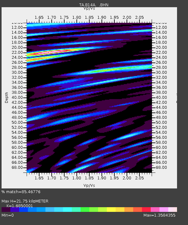
| Estimated Moho Depth: |
21.75 km |
| Estimated Crust Vp/Vs: |
1.69 |
| Assumed Crust Vp: |
6.178 km/s |
| Estimated Crust Vs: |
3.667 km/s |
| Estimated Crust Poisson's Ratio: |
0.23 |
|
| Radial Match: |
85.46776 % |
| Radial Bump: |
400 |
| Transverse Match: |
73.126 % |
| Transverse Bump: |
400 |
| SOD ConfigId: |
2504 |
| Insert Time: |
2010-03-06 22:08:50.357 +0000 |
| GWidth: |
2.5 |
| Max Bumps: |
400 |
| Tol: |
0.001 |
|

Signal To Noise
| Channel | StoN | STA | LTA |
| TA:B14A: :BHN:20080719T22:51:22.048999Z | 51.471756 | 2.3938335E-6 | 4.6507708E-8 |
| TA:B14A: :BHE:20080719T22:51:22.048999Z | 8.688373 | 1.0805172E-6 | 1.2436358E-7 |
| TA:B14A: :BHZ:20080719T22:51:22.048999Z | 9.086871 | 8.04388E-7 | 8.852199E-8 |
| Arrivals |
| Ps | 2.5 SECOND |
| PpPs | 9.3 SECOND |
| PsPs/PpSs | 12 SECOND |


