You are here: Home > Network List > TA - USArray Transportable Network (new EarthScope stations) Stations List
> Station B14A Marquette Ranch, East Glacier, MT, USA > Earthquake Result Viewer
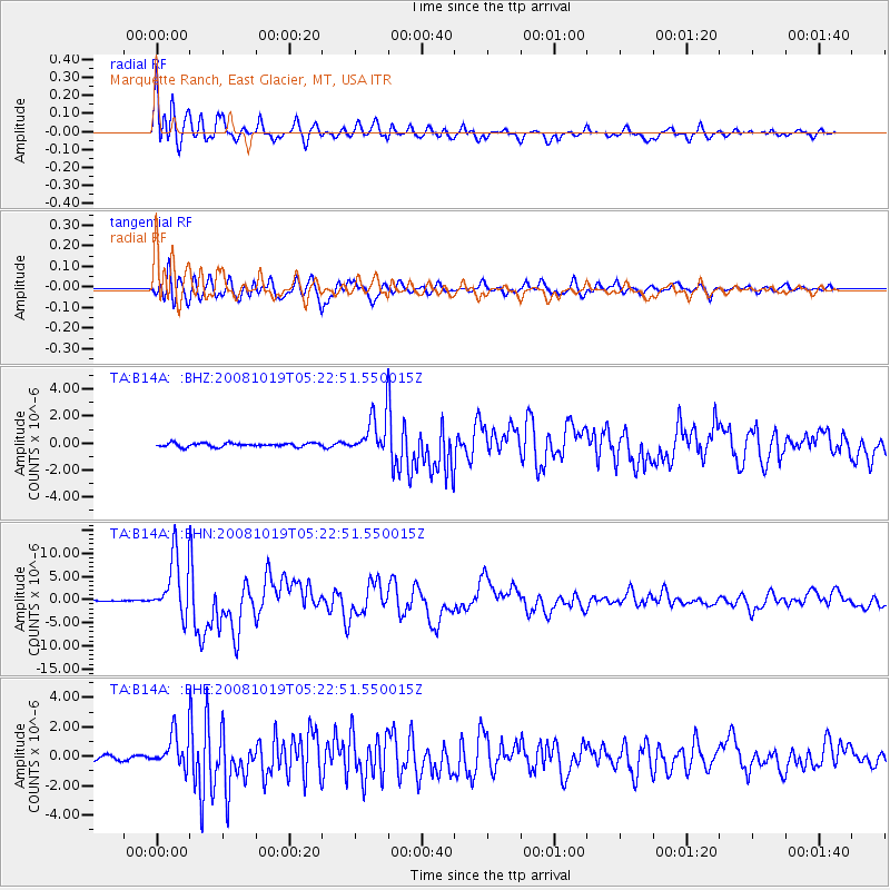
B14A Marquette Ranch, East Glacier, MT, USA - Earthquake Result Viewer
| Earthquake location: |
Tonga Islands |
| Earthquake latitude/longitude: |
-21.9/-173.8 |
| Earthquake time(UTC): |
2008/10/19 (293) 05:10:33 GMT |
| Earthquake Depth: |
29 km |
| Earthquake Magnitude: |
6.8 MB, 7.0 MS, 6.9 MW, 6.9 MW |
| Earthquake Catalog/Contributor: |
WHDF/NEIC |
|
| Network: |
TA USArray Transportable Network (new EarthScope stations) |
| Station: |
B14A Marquette Ranch, East Glacier, MT, USA |
| Lat/Lon: |
48.36 N/113.27 W |
| Elevation: |
1529 m |
|
| Distance: |
88.4 deg |
| Az: |
35.519 deg |
| Baz: |
234.019 deg |
| Ray Param: |
0.04261617 |
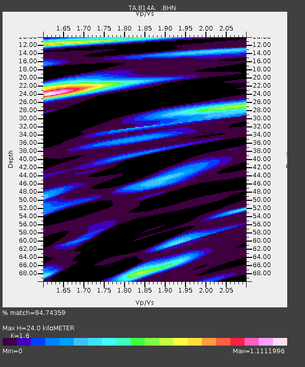
| Estimated Moho Depth: |
24.0 km |
| Estimated Crust Vp/Vs: |
1.60 |
| Assumed Crust Vp: |
6.178 km/s |
| Estimated Crust Vs: |
3.861 km/s |
| Estimated Crust Poisson's Ratio: |
0.18 |
|
| Radial Match: |
94.74359 % |
| Radial Bump: |
400 |
| Transverse Match: |
89.15683 % |
| Transverse Bump: |
400 |
| SOD ConfigId: |
2556 |
| Insert Time: |
2010-03-06 22:08:56.989 +0000 |
| GWidth: |
2.5 |
| Max Bumps: |
400 |
| Tol: |
0.001 |
|
Signal To Noise
| Channel | StoN | STA | LTA |
| TA:B14A: :BHN:20081019T05:22:51.550015Z | 42.836494 | 6.409724E-6 | 1.4963231E-7 |
| TA:B14A: :BHE:20081019T05:22:51.550015Z | 5.845176 | 1.1302892E-6 | 1.9337128E-7 |
| TA:B14A: :BHZ:20081019T05:22:51.550015Z | 10.407538 | 1.4295849E-6 | 1.3736053E-7 |
| Arrivals |
| Ps | 2.4 SECOND |
| PpPs | 9.9 SECOND |
| PsPs/PpSs | 12 SECOND |


