You are here: Home > Network List > TA - USArray Transportable Network (new EarthScope stations) Stations List
> Station B14A Marquette Ranch, East Glacier, MT, USA > Earthquake Result Viewer
B14A Marquette Ranch, East Glacier, MT, USA - Earthquake Result Viewer
| Earthquake location: |
Off Coast Of Jalisco, Mexico |
| Earthquake latitude/longitude: |
17.6/-105.5 |
| Earthquake time(UTC): |
2008/09/24 (268) 02:33:05 GMT |
| Earthquake Depth: |
10 km |
| Earthquake Magnitude: |
5.7 MB, 6.2 MS, 6.4 MW, 6.4 MW |
| Earthquake Catalog/Contributor: |
WHDF/NEIC |
|
| Network: |
TA USArray Transportable Network (new EarthScope stations) |
| Station: |
B14A Marquette Ranch, East Glacier, MT, USA |
| Lat/Lon: |
48.36 N/113.27 W |
| Elevation: |
1529 m |
|
| Distance: |
31.3 deg |
| Az: |
350.008 deg |
| Baz: |
165.634 deg |
| Ray Param: |
0.07909942 |
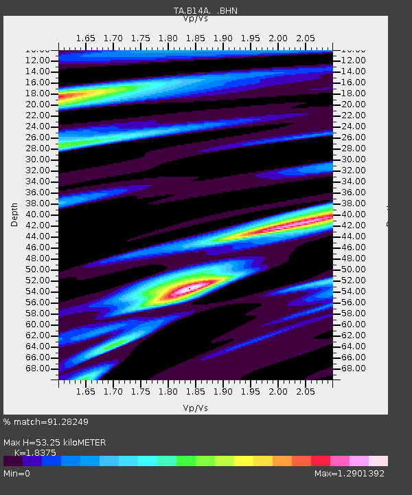
| Estimated Moho Depth: |
53.25 km |
| Estimated Crust Vp/Vs: |
1.84 |
| Assumed Crust Vp: |
6.178 km/s |
| Estimated Crust Vs: |
3.362 km/s |
| Estimated Crust Poisson's Ratio: |
0.29 |
|
| Radial Match: |
91.28249 % |
| Radial Bump: |
360 |
| Transverse Match: |
73.98767 % |
| Transverse Bump: |
400 |
| SOD ConfigId: |
2560 |
| Insert Time: |
2010-03-06 22:09:00.352 +0000 |
| GWidth: |
2.5 |
| Max Bumps: |
400 |
| Tol: |
0.001 |
|

Signal To Noise
| Channel | StoN | STA | LTA |
| TA:B14A: :BHN:20080924T02:38:54.92401Z | 26.59458 | 1.8755192E-6 | 7.052261E-8 |
| TA:B14A: :BHE:20080924T02:38:54.92401Z | 7.414896 | 9.594783E-7 | 1.2939876E-7 |
| TA:B14A: :BHZ:20080924T02:38:54.92401Z | 3.4600832 | 4.134015E-7 | 1.1947733E-7 |
| Arrivals |
| Ps | 7.7 SECOND |
| PpPs | 23 SECOND |
| PsPs/PpSs | 31 SECOND |


