You are here: Home > Network List > TA - USArray Transportable Network (new EarthScope stations) Stations List
> Station B14A Marquette Ranch, East Glacier, MT, USA > Earthquake Result Viewer
B14A Marquette Ranch, East Glacier, MT, USA - Earthquake Result Viewer
| Earthquake location: |
Kermadec Islands, New Zealand |
| Earthquake latitude/longitude: |
-29.8/-177.7 |
| Earthquake time(UTC): |
2008/09/29 (273) 15:19:31 GMT |
| Earthquake Depth: |
36 km |
| Earthquake Magnitude: |
6.5 MB, 6.7 MS, 7.0 MW, 7.0 MW |
| Earthquake Catalog/Contributor: |
WHDF/NEIC |
|
| Network: |
TA USArray Transportable Network (new EarthScope stations) |
| Station: |
B14A Marquette Ranch, East Glacier, MT, USA |
| Lat/Lon: |
48.36 N/113.27 W |
| Elevation: |
1529 m |
|
| Distance: |
96.7 deg |
| Az: |
37.279 deg |
| Baz: |
232.162 deg |
| Ray Param: |
0.040404633 |
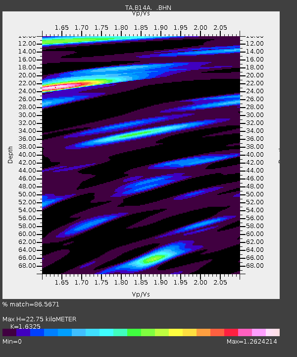
| Estimated Moho Depth: |
22.75 km |
| Estimated Crust Vp/Vs: |
1.63 |
| Assumed Crust Vp: |
6.178 km/s |
| Estimated Crust Vs: |
3.785 km/s |
| Estimated Crust Poisson's Ratio: |
0.20 |
|
| Radial Match: |
86.5671 % |
| Radial Bump: |
400 |
| Transverse Match: |
79.653656 % |
| Transverse Bump: |
400 |
| SOD ConfigId: |
2560 |
| Insert Time: |
2010-03-06 22:09:02.283 +0000 |
| GWidth: |
2.5 |
| Max Bumps: |
400 |
| Tol: |
0.001 |
|
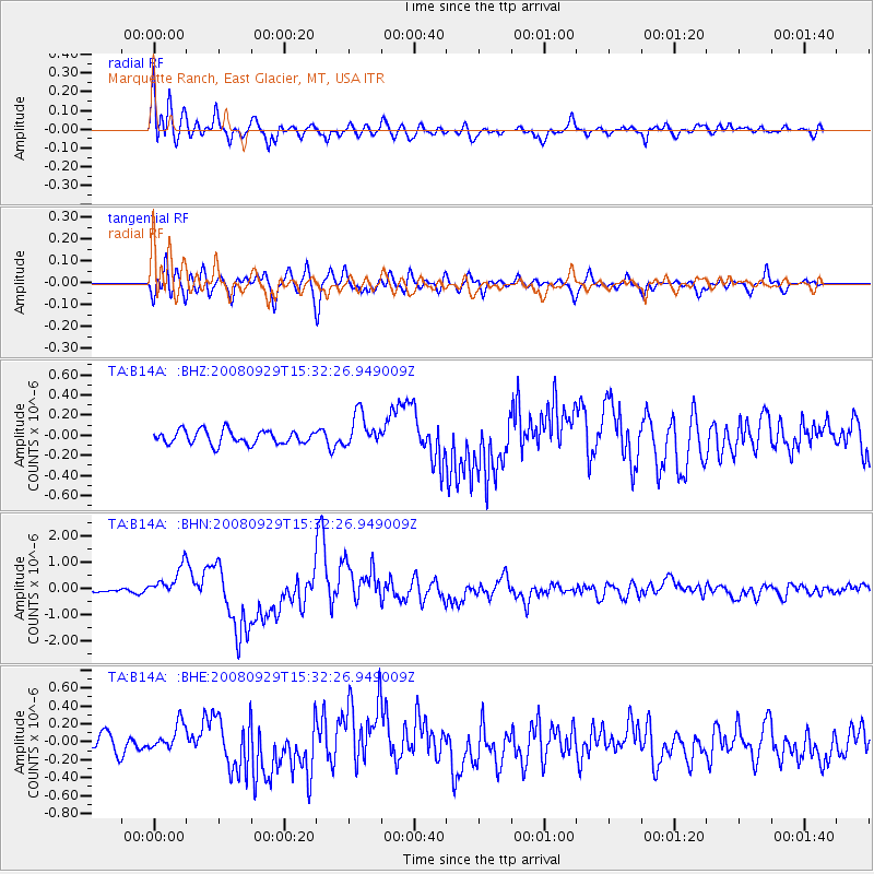
Signal To Noise
| Channel | StoN | STA | LTA |
| TA:B14A: :BHN:20080929T15:32:26.949009Z | 7.360433 | 5.808264E-7 | 7.891199E-8 |
| TA:B14A: :BHE:20080929T15:32:26.949009Z | 1.8892492 | 1.5514273E-7 | 8.2118724E-8 |
| TA:B14A: :BHZ:20080929T15:32:26.949009Z | 2.4394615 | 1.6541031E-7 | 6.780608E-8 |
| Arrivals |
| Ps | 2.4 SECOND |
| PpPs | 9.5 SECOND |
| PsPs/PpSs | 12 SECOND |


