You are here: Home > Network List > TA - USArray Transportable Network (new EarthScope stations) Stations List
> Station B14A Marquette Ranch, East Glacier, MT, USA > Earthquake Result Viewer
B14A Marquette Ranch, East Glacier, MT, USA - Earthquake Result Viewer
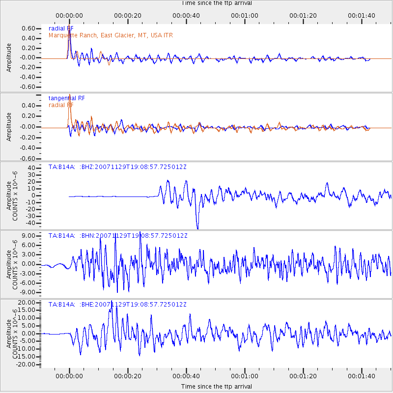
| Earthquake location: |
Windward Islands |
| Earthquake latitude/longitude: |
15.0/-61.3 |
| Earthquake time(UTC): |
2007/11/29 (333) 19:00:19 GMT |
| Earthquake Depth: |
148 km |
| Earthquake Magnitude: |
6.9 MB, 7.4 MW, 7.4 MW |
| Earthquake Catalog/Contributor: |
WHDF/NEIC |
|
| Network: |
TA USArray Transportable Network (new EarthScope stations) |
| Station: |
B14A Marquette Ranch, East Glacier, MT, USA |
| Lat/Lon: |
48.36 N/113.27 W |
| Elevation: |
1529 m |
|
| Distance: |
54.0 deg |
| Az: |
319.469 deg |
| Baz: |
109.654 deg |
| Ray Param: |
0.06526534 |
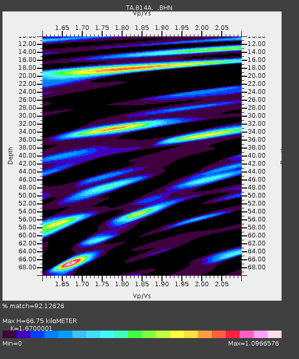
| Estimated Moho Depth: |
66.75 km |
| Estimated Crust Vp/Vs: |
1.67 |
| Assumed Crust Vp: |
6.178 km/s |
| Estimated Crust Vs: |
3.7 km/s |
| Estimated Crust Poisson's Ratio: |
0.22 |
|
| Radial Match: |
92.12626 % |
| Radial Bump: |
400 |
| Transverse Match: |
82.212395 % |
| Transverse Bump: |
400 |
| SOD ConfigId: |
2564 |
| Insert Time: |
2010-03-06 22:09:20.110 +0000 |
| GWidth: |
2.5 |
| Max Bumps: |
400 |
| Tol: |
0.001 |
|
Signal To Noise
| Channel | StoN | STA | LTA |
| TA:B14A: :BHN:20071129T19:08:57.725012Z | 10.102982 | 1.8402837E-6 | 1.8215255E-7 |
| TA:B14A: :BHE:20071129T19:08:57.725012Z | 12.862239 | 5.1543693E-6 | 4.0073652E-7 |
| TA:B14A: :BHZ:20071129T19:08:57.725012Z | 41.736607 | 1.0858107E-5 | 2.601579E-7 |
| Arrivals |
| Ps | 7.6 SECOND |
| PpPs | 27 SECOND |
| PsPs/PpSs | 35 SECOND |


