You are here: Home > Network List > TA - USArray Transportable Network (new EarthScope stations) Stations List
> Station B14A Marquette Ranch, East Glacier, MT, USA > Earthquake Result Viewer
B14A Marquette Ranch, East Glacier, MT, USA - Earthquake Result Viewer
| Earthquake location: |
Hokkaido, Japan Region |
| Earthquake latitude/longitude: |
41.8/143.4 |
| Earthquake time(UTC): |
2009/06/05 (156) 03:30:33 GMT |
| Earthquake Depth: |
29 km |
| Earthquake Magnitude: |
6.0 MB, 6.3 MS, 6.4 MW, 6.4 MW |
| Earthquake Catalog/Contributor: |
WHDF/NEIC |
|
| Network: |
TA USArray Transportable Network (new EarthScope stations) |
| Station: |
B14A Marquette Ranch, East Glacier, MT, USA |
| Lat/Lon: |
48.36 N/113.27 W |
| Elevation: |
1529 m |
|
| Distance: |
67.6 deg |
| Az: |
44.578 deg |
| Baz: |
308.132 deg |
| Ray Param: |
0.0567863 |
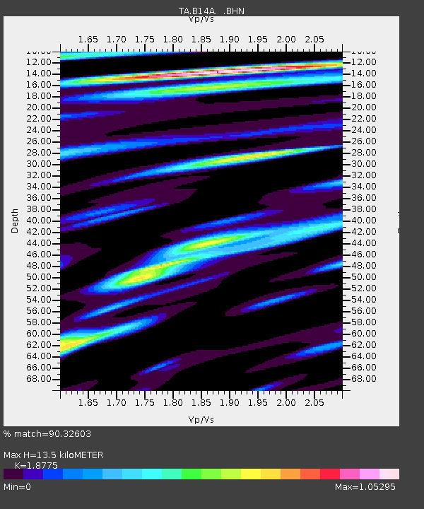
| Estimated Moho Depth: |
13.5 km |
| Estimated Crust Vp/Vs: |
1.88 |
| Assumed Crust Vp: |
6.178 km/s |
| Estimated Crust Vs: |
3.291 km/s |
| Estimated Crust Poisson's Ratio: |
0.30 |
|
| Radial Match: |
90.32603 % |
| Radial Bump: |
400 |
| Transverse Match: |
88.37539 % |
| Transverse Bump: |
400 |
| SOD ConfigId: |
2648 |
| Insert Time: |
2010-03-06 22:09:25.653 +0000 |
| GWidth: |
2.5 |
| Max Bumps: |
400 |
| Tol: |
0.001 |
|

Signal To Noise
| Channel | StoN | STA | LTA |
| TA:B14A: :BHN:20090605T03:40:56.224001Z | 13.003671 | 7.223028E-7 | 5.5546067E-8 |
| TA:B14A: :BHE:20090605T03:40:56.224001Z | 4.0201325 | 2.3292075E-7 | 5.793858E-8 |
| TA:B14A: :BHZ:20090605T03:40:56.224001Z | 3.7920694 | 1.6319983E-7 | 4.303714E-8 |
| Arrivals |
| Ps | 2.0 SECOND |
| PpPs | 6.1 SECOND |
| PsPs/PpSs | 8.1 SECOND |


